You are here: Home > Network List > TA - USArray Transportable Network (new EarthScope stations) Stations List
> Station Q19K Cape Douglas, AK, USA > Earthquake Result Viewer
Q19K Cape Douglas, AK, USA - Earthquake Result Viewer
| Earthquake location: |
Kyushu, Japan |
| Earthquake latitude/longitude: |
32.8/130.7 |
| Earthquake time(UTC): |
2016/04/15 (106) 16:25:06 GMT |
| Earthquake Depth: |
10 km |
| Earthquake Magnitude: |
7.0 MO |
| Earthquake Catalog/Contributor: |
NEIC PDE/NEIC ALERT |
|
| Network: |
TA USArray Transportable Network (new EarthScope stations) |
| Station: |
Q19K Cape Douglas, AK, USA |
| Lat/Lon: |
58.93 N/153.64 W |
| Elevation: |
631 m |
|
| Distance: |
55.3 deg |
| Az: |
37.666 deg |
| Baz: |
277.037 deg |
| Ray Param: |
0.0648782 |
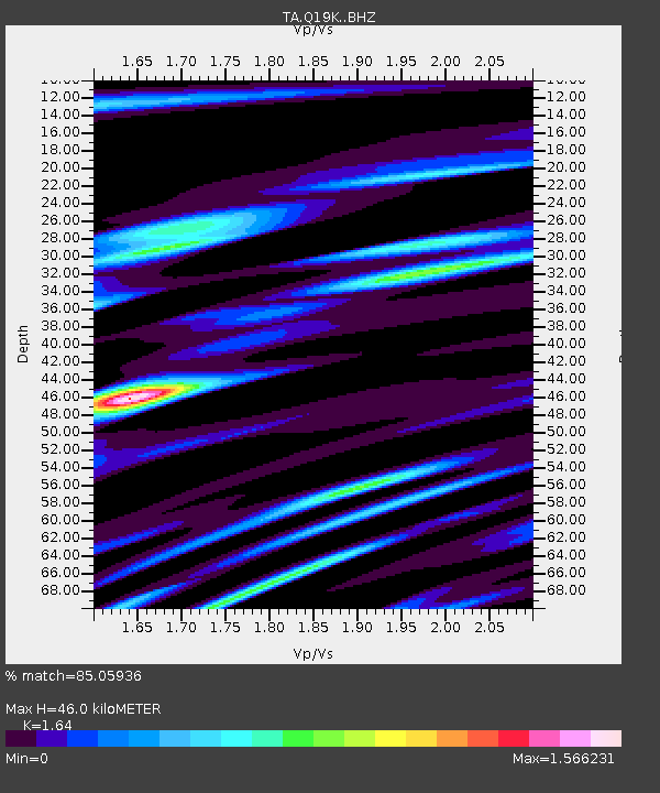
| Estimated Moho Depth: |
46.0 km |
| Estimated Crust Vp/Vs: |
1.64 |
| Assumed Crust Vp: |
5.989 km/s |
| Estimated Crust Vs: |
3.652 km/s |
| Estimated Crust Poisson's Ratio: |
0.20 |
|
| Radial Match: |
85.05936 % |
| Radial Bump: |
400 |
| Transverse Match: |
81.32779 % |
| Transverse Bump: |
400 |
| SOD ConfigId: |
7422571 |
| Insert Time: |
2019-04-22 07:15:47.898 +0000 |
| GWidth: |
2.5 |
| Max Bumps: |
400 |
| Tol: |
0.001 |
|

Signal To Noise
| Channel | StoN | STA | LTA |
| TA:Q19K: :BHZ:20160415T16:34:08.674988Z | 8.184129 | 3.1724182E-6 | 3.8763056E-7 |
| TA:Q19K: :BHN:20160415T16:34:08.674988Z | 0.8738764 | 4.5338453E-7 | 5.1882E-7 |
| TA:Q19K: :BHE:20160415T16:34:08.674988Z | 1.7432241 | 1.330422E-6 | 7.6319617E-7 |
| Arrivals |
| Ps | 5.2 SECOND |
| PpPs | 19 SECOND |
| PsPs/PpSs | 24 SECOND |


