You are here: Home > Network List > TJ - Tajikistan National Seismic Network Stations List
> Station CHGR Chuyangaron, Tajikistan > Earthquake Result Viewer
CHGR Chuyangaron, Tajikistan - Earthquake Result Viewer
| Earthquake location: |
Kyushu, Japan |
| Earthquake latitude/longitude: |
32.8/130.7 |
| Earthquake time(UTC): |
2016/04/15 (106) 16:25:06 GMT |
| Earthquake Depth: |
10 km |
| Earthquake Magnitude: |
7.0 MO |
| Earthquake Catalog/Contributor: |
NEIC PDE/NEIC ALERT |
|
| Network: |
TJ Tajikistan National Seismic Network |
| Station: |
CHGR Chuyangaron, Tajikistan |
| Lat/Lon: |
38.66 N/69.16 E |
| Elevation: |
1049 m |
|
| Distance: |
49.5 deg |
| Az: |
295.144 deg |
| Baz: |
76.899 deg |
| Ray Param: |
0.068651505 |
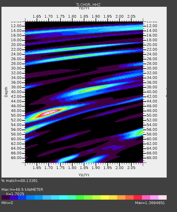
| Estimated Moho Depth: |
48.5 km |
| Estimated Crust Vp/Vs: |
1.70 |
| Assumed Crust Vp: |
6.483 km/s |
| Estimated Crust Vs: |
3.808 km/s |
| Estimated Crust Poisson's Ratio: |
0.24 |
|
| Radial Match: |
88.13391 % |
| Radial Bump: |
400 |
| Transverse Match: |
84.329384 % |
| Transverse Bump: |
400 |
| SOD ConfigId: |
7422571 |
| Insert Time: |
2019-04-22 07:15:54.462 +0000 |
| GWidth: |
2.5 |
| Max Bumps: |
400 |
| Tol: |
0.001 |
|

Signal To Noise
| Channel | StoN | STA | LTA |
| TJ:CHGR: :HHZ:20160415T16:33:26.049988Z | 4.5055847 | 5.995157E-7 | 1.3306058E-7 |
| TJ:CHGR: :HHN:20160415T16:33:26.049988Z | 0.9562334 | 9.7884346E-8 | 1.02364496E-7 |
| TJ:CHGR: :HHE:20160415T16:33:26.049988Z | 3.3110857 | 2.968972E-7 | 8.966763E-8 |
| Arrivals |
| Ps | 5.6 SECOND |
| PpPs | 19 SECOND |
| PsPs/PpSs | 25 SECOND |


