You are here: Home > Network List > US - United States National Seismic Network Stations List
> Station BLA Blacksburg, Virginia, USA > Earthquake Result Viewer
BLA Blacksburg, Virginia, USA - Earthquake Result Viewer
| Earthquake location: |
Kuril Islands |
| Earthquake latitude/longitude: |
47.2/151.3 |
| Earthquake time(UTC): |
2004/07/08 (190) 10:30:49 GMT |
| Earthquake Depth: |
128 km |
| Earthquake Magnitude: |
5.9 MB, 6.4 MW, 6.3 MW |
| Earthquake Catalog/Contributor: |
WHDF/NEIC |
|
| Network: |
US United States National Seismic Network |
| Station: |
BLA Blacksburg, Virginia, USA |
| Lat/Lon: |
37.21 N/80.42 W |
| Elevation: |
634 m |
|
| Distance: |
84.1 deg |
| Az: |
39.058 deg |
| Baz: |
327.438 deg |
| Ray Param: |
0.045451127 |
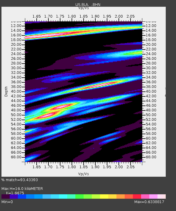
| Estimated Moho Depth: |
16.0 km |
| Estimated Crust Vp/Vs: |
1.67 |
| Assumed Crust Vp: |
6.159 km/s |
| Estimated Crust Vs: |
3.693 km/s |
| Estimated Crust Poisson's Ratio: |
0.22 |
|
| Radial Match: |
93.43393 % |
| Radial Bump: |
400 |
| Transverse Match: |
77.81952 % |
| Transverse Bump: |
400 |
| SOD ConfigId: |
110177 |
| Insert Time: |
2010-03-05 01:32:57.764 +0000 |
| GWidth: |
2.5 |
| Max Bumps: |
400 |
| Tol: |
0.001 |
|
Signal To Noise
| Channel | StoN | STA | LTA |
| US:BLA: :BHN:20040708T10:42:34.376003Z | 4.356575 | 2.1893509E-7 | 5.0253945E-8 |
| US:BLA: :BHE:20040708T10:42:34.376003Z | 3.0050676 | 1.7796435E-7 | 5.9221417E-8 |
| US:BLA: :BHZ:20040708T10:42:34.376003Z | 10.9752035 | 8.191879E-7 | 7.463988E-8 |
| Arrivals |
| Ps | 1.8 SECOND |
| PpPs | 6.8 SECOND |
| PsPs/PpSs | 8.5 SECOND |


