You are here: Home > Network List > X614 - Homestake Gold Mine Three dimensional Broadband Array Stations List
> Station B4850 4850 level Homestake mine - near shaft 6 > Earthquake Result Viewer
B4850 4850 level Homestake mine - near shaft 6 - Earthquake Result Viewer
| Earthquake location: |
Kyushu, Japan |
| Earthquake latitude/longitude: |
32.8/130.7 |
| Earthquake time(UTC): |
2016/04/15 (106) 16:25:06 GMT |
| Earthquake Depth: |
10 km |
| Earthquake Magnitude: |
7.0 MO |
| Earthquake Catalog/Contributor: |
NEIC PDE/NEIC ALERT |
|
| Network: |
X6 Homestake Gold Mine Three dimensional Broadband Array |
| Station: |
B4850 4850 level Homestake mine - near shaft 6 |
| Lat/Lon: |
44.35 N/103.76 W |
| Elevation: |
115 m |
|
| Distance: |
88.6 deg |
| Az: |
35.744 deg |
| Baz: |
316.696 deg |
| Ray Param: |
0.042458903 |
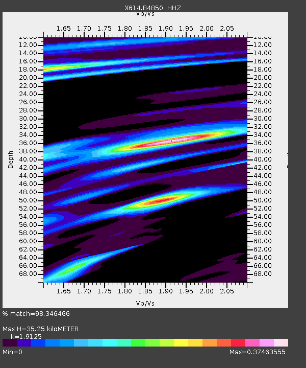
| Estimated Moho Depth: |
35.25 km |
| Estimated Crust Vp/Vs: |
1.91 |
| Assumed Crust Vp: |
6.242 km/s |
| Estimated Crust Vs: |
3.264 km/s |
| Estimated Crust Poisson's Ratio: |
0.31 |
|
| Radial Match: |
98.346466 % |
| Radial Bump: |
223 |
| Transverse Match: |
91.99885 % |
| Transverse Bump: |
322 |
| SOD ConfigId: |
7422571 |
| Insert Time: |
2019-04-22 07:16:47.378 +0000 |
| GWidth: |
2.5 |
| Max Bumps: |
400 |
| Tol: |
0.001 |
|

Signal To Noise
| Channel | StoN | STA | LTA |
| X6:B4850: :HHZ:20160415T16:37:27.658997Z | 5.924971 | 6.9259283E-7 | 1.1689387E-7 |
| X6:B4850: :HHN:20160415T16:37:27.658997Z | 3.5713143 | 2.6268594E-7 | 7.355442E-8 |
| X6:B4850: :HHE:20160415T16:37:27.658997Z | 2.244178 | 1.923031E-7 | 8.568978E-8 |
| Arrivals |
| Ps | 5.3 SECOND |
| PpPs | 16 SECOND |
| PsPs/PpSs | 21 SECOND |


