You are here: Home > Network List > US - United States National Seismic Network Stations List
> Station BLA Blacksburg, Virginia, USA > Earthquake Result Viewer
BLA Blacksburg, Virginia, USA - Earthquake Result Viewer
| Earthquake location: |
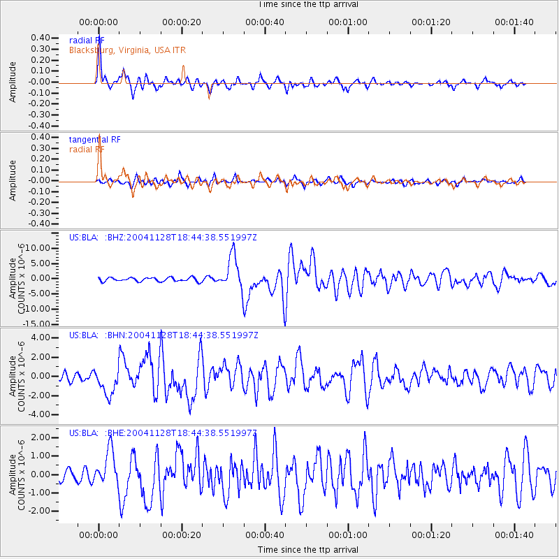
Hokkaido, Japan Region |
| Earthquake latitude/longitude: |
43.0/145.1 |
| Earthquake time(UTC): |
2004/11/28 (333) 18:32:14 GMT |
| Earthquake Depth: |
39 km |
| Earthquake Magnitude: |
6.4 MB, 6.7 MS, 7.0 MW, 7.0 MW |
| Earthquake Catalog/Contributor: |
WHDF/NEIC |
|
| Network: |
US United States National Seismic Network |
| Station: |
BLA Blacksburg, Virginia, USA |
| Lat/Lon: |
37.21 N/80.42 W |
| Elevation: |
634 m |
|
| Distance: |
90.1 deg |
| Az: |
34.738 deg |
| Baz: |
328.428 deg |
| Ray Param: |
0.041695505 |
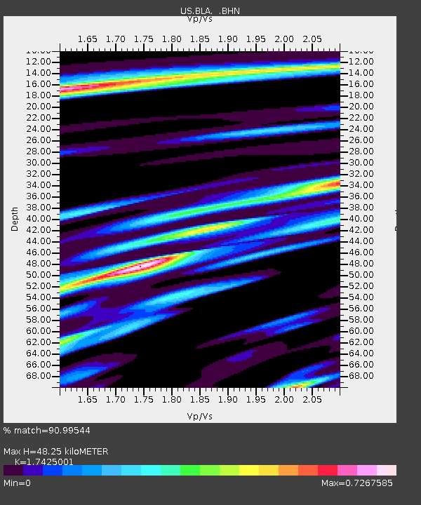
| Estimated Moho Depth: |
48.25 km |
| Estimated Crust Vp/Vs: |
1.74 |
| Assumed Crust Vp: |
6.159 km/s |
| Estimated Crust Vs: |
3.534 km/s |
| Estimated Crust Poisson's Ratio: |
0.25 |
|
| Radial Match: |
90.99544 % |
| Radial Bump: |
400 |
| Transverse Match: |
78.42676 % |
| Transverse Bump: |
400 |
| SOD ConfigId: |
110177 |
| Insert Time: |
2010-03-05 01:33:09.613 +0000 |
| GWidth: |
2.5 |
| Max Bumps: |
400 |
| Tol: |
0.001 |
|
Signal To Noise
| Channel | StoN | STA | LTA |
| US:BLA: :BHN:20041128T18:44:38.551997Z | 3.7598019 | 1.4340754E-6 | 3.8142315E-7 |
| US:BLA: :BHE:20041128T18:44:38.551997Z | 2.423344 | 9.934568E-7 | 4.0995283E-7 |
| US:BLA: :BHZ:20041128T18:44:38.551997Z | 9.443491 | 5.822342E-6 | 6.165455E-7 |
| Arrivals |
| Ps | 5.9 SECOND |
| PpPs | 21 SECOND |
| PsPs/PpSs | 27 SECOND |


