You are here: Home > Network List > XD14 - Illuminating the architecture of the greater Mount St. Helens magmatic systems f Stations List
> Station ML10 "Mount St Helens, WA" > Earthquake Result Viewer
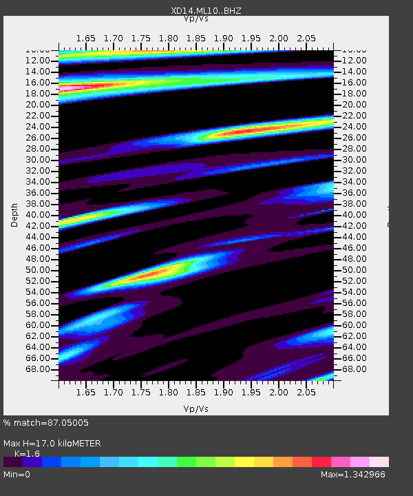
ML10 "Mount St Helens, WA" - Earthquake Result Viewer
| Earthquake location: |
Kyushu, Japan |
| Earthquake latitude/longitude: |
32.8/130.7 |
| Earthquake time(UTC): |
2016/04/15 (106) 16:25:06 GMT |
| Earthquake Depth: |
10 km |
| Earthquake Magnitude: |
7.0 MO |
| Earthquake Catalog/Contributor: |
NEIC PDE/NEIC ALERT |
|
| Network: |
XD Illuminating the architecture of the greater Mount St. Helens magmatic systems f |
| Station: |
ML10 "Mount St Helens, WA" |
| Lat/Lon: |
46.05 N/121.75 W |
| Elevation: |
1238 m |
|
| Distance: |
77.9 deg |
| Az: |
42.785 deg |
| Baz: |
304.751 deg |
| Ray Param: |
0.05002662 |
| Estimated Moho Depth: |
17.0 km |
| Estimated Crust Vp/Vs: |
1.60 |
| Assumed Crust Vp: |
6.597 km/s |
| Estimated Crust Vs: |
4.123 km/s |
| Estimated Crust Poisson's Ratio: |
0.18 |
|
| Radial Match: |
87.05005 % |
| Radial Bump: |
400 |
| Transverse Match: |
79.95926 % |
| Transverse Bump: |
400 |
| SOD ConfigId: |
7422571 |
| Insert Time: |
2019-04-22 07:17:24.857 +0000 |
| GWidth: |
2.5 |
| Max Bumps: |
400 |
| Tol: |
0.001 |
|

Signal To Noise
| Channel | StoN | STA | LTA |
| XD:ML10: :BHZ:20160415T16:36:32.48999Z | 2.3721936 | 1.274394E-6 | 5.3722175E-7 |
| XD:ML10: :BHN:20160415T16:36:32.48999Z | 1.2604288 | 7.2085186E-7 | 5.7191005E-7 |
| XD:ML10: :BHE:20160415T16:36:32.48999Z | 1.3121772 | 7.228905E-7 | 5.509092E-7 |
| Arrivals |
| Ps | 1.6 SECOND |
| PpPs | 6.5 SECOND |
| PsPs/PpSs | 8.1 SECOND |


