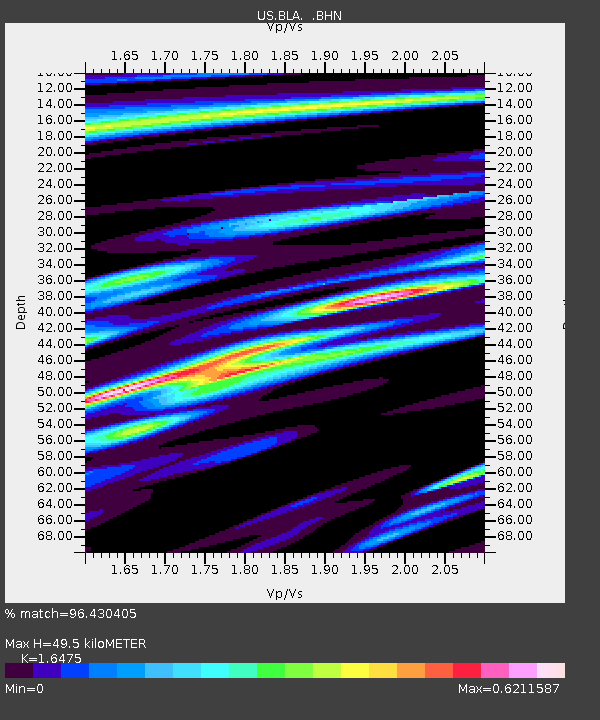
BLA Blacksburg, Virginia, USA - Earthquake Result Viewer
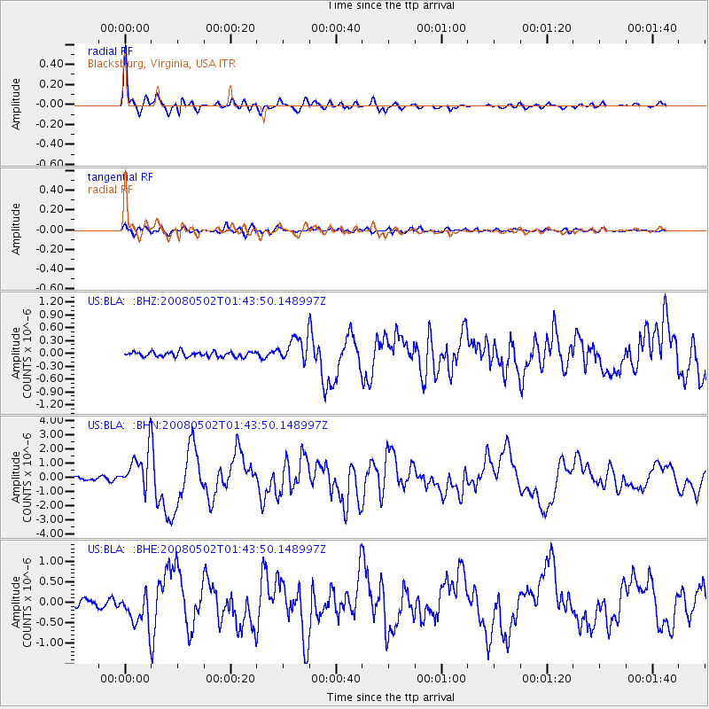
Earthquake location: Andreanof Islands, Aleutian Is.
Earthquake latitude/longitude: 51.9/-177.5
Earthquake time(UTC): 2008/05/02 (123) 01:33:37 GMT
Earthquake Depth: 14 km
Earthquake Magnitude: 6.3 MB, 6.8 MS, 6.6 MW, 6.6 MW
Earthquake Catalog/Contributor: WHDF/NEIC
Network: US United States National Seismic Network
Station: BLA Blacksburg, Virginia, USA
Lat/Lon: 37.21 N/80.42 W
Elevation: 634 m
Distance: 65.7 deg
Az: 60.353 deg
Baz: 317.543 deg
Ray Param: 0.058077317
Estimated Moho Depth: 49.5 km
Estimated Crust Vp/Vs: 1.65
Assumed Crust Vp: 6.159 km/s
Estimated Crust Vs: 3.738 km/s
Estimated Crust Poisson's Ratio: 0.21
Radial Match: 96.430405 %
Radial Bump: 361
Transverse Match: 84.30467 %
Transverse Bump: 400
SOD ConfigId: 2504
Insert Time: 2010-03-05 01:33:33.622 +0000
GWidth: 2.5
Max Bumps: 400
Tol: 0.001

Signal To Noise

ChannelStoNSTALTA
US:BLA: :BHN:20080502T01:43:50.148997Z14.1489921.3846748E-69.786385E-8
US:BLA: :BHE:20080502T01:43:50.148997Z5.99222854.1869822E-76.987354E-8
US:BLA: :BHZ:20080502T01:43:50.148997Z5.0864142.950162E-75.800083E-8
Arrivals
Ps5.4 SECOND
PpPs20 SECOND
PsPs/PpSs26 SECOND