You are here: Home > Network List > NM - Cooperative New Madrid Seismic Network Stations List
> Station GNAR Gosnell,AR > Earthquake Result Viewer
GNAR Gosnell,AR - Earthquake Result Viewer
| Earthquake location: |
Southern Alaska |
| Earthquake latitude/longitude: |
59.9/-153.1 |
| Earthquake time(UTC): |
2015/07/29 (210) 02:35:58 GMT |
| Earthquake Depth: |
118 km |
| Earthquake Magnitude: |
6.3 ML, 6.2 MWP, 6.2 MI, 6.3 MWW |
| Earthquake Catalog/Contributor: |
NEIC PDE/NEIC COMCAT |
|
| Network: |
NM Cooperative New Madrid Seismic Network |
| Station: |
GNAR Gosnell,AR |
| Lat/Lon: |
35.97 N/90.02 W |
| Elevation: |
71 m |
|
| Distance: |
46.3 deg |
| Az: |
91.802 deg |
| Baz: |
321.607 deg |
| Ray Param: |
0.07029205 |
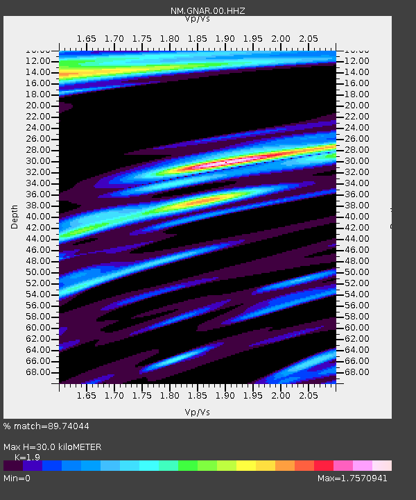
| Estimated Moho Depth: |
30.0 km |
| Estimated Crust Vp/Vs: |
1.90 |
| Assumed Crust Vp: |
6.273 km/s |
| Estimated Crust Vs: |
3.302 km/s |
| Estimated Crust Poisson's Ratio: |
0.31 |
|
| Radial Match: |
89.74044 % |
| Radial Bump: |
400 |
| Transverse Match: |
78.51771 % |
| Transverse Bump: |
400 |
| SOD ConfigId: |
1085051 |
| Insert Time: |
2015-08-12 03:05:07.616 +0000 |
| GWidth: |
2.5 |
| Max Bumps: |
400 |
| Tol: |
0.001 |
|

Signal To Noise
| Channel | StoN | STA | LTA |
| NM:GNAR:00:HHZ:20150729T02:43:41.714996Z | 7.324894 | 1.3250789E-6 | 1.8090076E-7 |
| NM:GNAR:00:HHN:20150729T02:43:41.714996Z | 2.0033185 | 6.244646E-7 | 3.117151E-7 |
| NM:GNAR:00:HHE:20150729T02:43:41.714996Z | 0.85419977 | 4.1808082E-7 | 4.894415E-7 |
| Arrivals |
| Ps | 4.5 SECOND |
| PpPs | 13 SECOND |
| PsPs/PpSs | 18 SECOND |


