You are here: Home > Network List > CI - Caltech Regional Seismic Network Stations List
> Station MPM Manuel Prospect Mine, California, USA > Earthquake Result Viewer
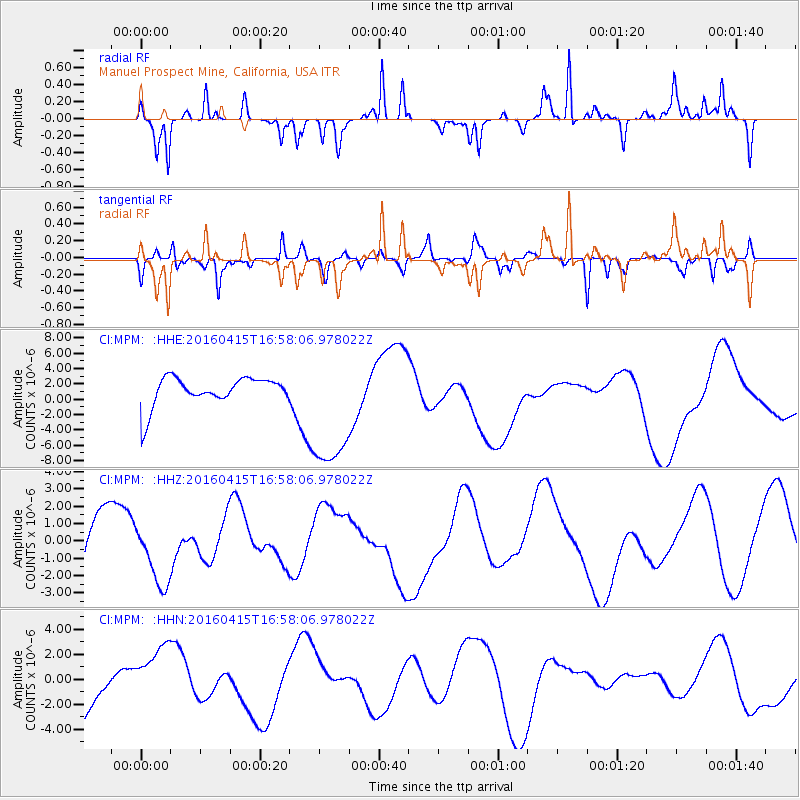
MPM Manuel Prospect Mine, California, USA - Earthquake Result Viewer
*The percent match for this event was below the threshold and hence no stack was calculated.
| Earthquake location: |
Kyushu, Japan |
| Earthquake latitude/longitude: |
32.9/130.8 |
| Earthquake time(UTC): |
2016/04/15 (106) 16:45:56 GMT |
| Earthquake Depth: |
10 km |
| Earthquake Magnitude: |
5.7 MB |
| Earthquake Catalog/Contributor: |
NEIC PDE/NEIC COMCAT |
|
| Network: |
CI Caltech Regional Seismic Network |
| Station: |
MPM Manuel Prospect Mine, California, USA |
| Lat/Lon: |
36.06 N/117.49 W |
| Elevation: |
185 m |
|
| Distance: |
86.3 deg |
| Az: |
48.995 deg |
| Baz: |
308.402 deg |
| Ray Param: |
$rayparam |
*The percent match for this event was below the threshold and hence was not used in the summary stack. |
|
| Radial Match: |
63.88588 % |
| Radial Bump: |
207 |
| Transverse Match: |
58.808727 % |
| Transverse Bump: |
290 |
| SOD ConfigId: |
7422571 |
| Insert Time: |
2019-04-22 07:21:16.323 +0000 |
| GWidth: |
2.5 |
| Max Bumps: |
400 |
| Tol: |
0.001 |
|
Signal To Noise
| Channel | StoN | STA | LTA |
| CI:MPM: :HHZ:20160415T16:58:06.978022Z | 1.0303975 | 1.962643E-6 | 1.9047434E-6 |
| CI:MPM: :HHN:20160415T16:58:06.978022Z | 1.1869661 | 2.6146158E-6 | 2.202772E-6 |
| CI:MPM: :HHE:20160415T16:58:06.978022Z | 4.511512 | 8.464365E-6 | 1.8761704E-6 |
| Arrivals |
| Ps | |
| PpPs | |
| PsPs/PpSs | |


