You are here: Home > Network List > CN - Canadian National Seismograph Network Stations List
> Station INK INUVIK, NT > Earthquake Result Viewer
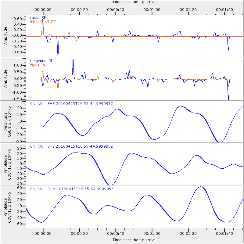
INK INUVIK, NT - Earthquake Result Viewer
*The percent match for this event was below the threshold and hence no stack was calculated.
| Earthquake location: |
Kyushu, Japan |
| Earthquake latitude/longitude: |
32.9/130.8 |
| Earthquake time(UTC): |
2016/04/15 (106) 16:45:56 GMT |
| Earthquake Depth: |
10 km |
| Earthquake Magnitude: |
5.7 MB |
| Earthquake Catalog/Contributor: |
NEIC PDE/NEIC COMCAT |
|
| Network: |
CN Canadian National Seismograph Network |
| Station: |
INK INUVIK, NT |
| Lat/Lon: |
68.31 N/133.53 W |
| Elevation: |
44 m |
|
| Distance: |
61.9 deg |
| Az: |
24.797 deg |
| Baz: |
288.334 deg |
| Ray Param: |
$rayparam |
*The percent match for this event was below the threshold and hence was not used in the summary stack. |
|
| Radial Match: |
73.37837 % |
| Radial Bump: |
267 |
| Transverse Match: |
67.732704 % |
| Transverse Bump: |
280 |
| SOD ConfigId: |
7422571 |
| Insert Time: |
2019-04-22 07:21:44.902 +0000 |
| GWidth: |
2.5 |
| Max Bumps: |
400 |
| Tol: |
0.001 |
|
Signal To Noise
| Channel | StoN | STA | LTA |
| CN:INK: :BHZ:20160415T16:55:44.999995Z | 2.0079238 | 1.9608051E-5 | 9.7653365E-6 |
| CN:INK: :BHN:20160415T16:55:44.999995Z | 1.3510287 | 4.83357E-5 | 3.577696E-5 |
| CN:INK: :BHE:20160415T16:55:44.999995Z | 0.5487914 | 6.492135E-6 | 1.1829878E-5 |
| Arrivals |
| Ps | |
| PpPs | |
| PsPs/PpSs | |


