You are here: Home > Network List > NM - Cooperative New Madrid Seismic Network Stations List
> Station SIUC Carbondale, IL > Earthquake Result Viewer
SIUC Carbondale, IL - Earthquake Result Viewer
| Earthquake location: |
Southern Alaska |
| Earthquake latitude/longitude: |
59.9/-153.1 |
| Earthquake time(UTC): |
2015/07/29 (210) 02:35:58 GMT |
| Earthquake Depth: |
118 km |
| Earthquake Magnitude: |
6.3 ML, 6.2 MWP, 6.2 MI, 6.3 MWW |
| Earthquake Catalog/Contributor: |
NEIC PDE/NEIC COMCAT |
|
| Network: |
NM Cooperative New Madrid Seismic Network |
| Station: |
SIUC Carbondale, IL |
| Lat/Lon: |
37.71 N/89.22 W |
| Elevation: |
120 m |
|
| Distance: |
45.4 deg |
| Az: |
89.577 deg |
| Baz: |
320.535 deg |
| Ray Param: |
0.07089268 |
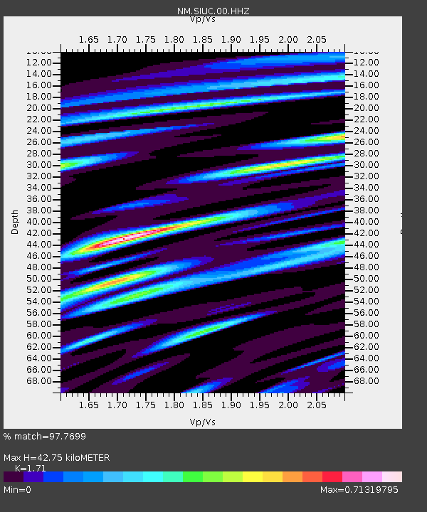
| Estimated Moho Depth: |
42.75 km |
| Estimated Crust Vp/Vs: |
1.71 |
| Assumed Crust Vp: |
6.444 km/s |
| Estimated Crust Vs: |
3.768 km/s |
| Estimated Crust Poisson's Ratio: |
0.24 |
|
| Radial Match: |
97.7699 % |
| Radial Bump: |
304 |
| Transverse Match: |
92.465614 % |
| Transverse Bump: |
400 |
| SOD ConfigId: |
1085051 |
| Insert Time: |
2015-08-12 03:05:41.381 +0000 |
| GWidth: |
2.5 |
| Max Bumps: |
400 |
| Tol: |
0.001 |
|

Signal To Noise
| Channel | StoN | STA | LTA |
| NM:SIUC:00:HHZ:20150729T02:43:34.178009Z | 13.045281 | 1.0859334E-6 | 8.3243386E-8 |
| NM:SIUC:00:HHN:20150729T02:43:34.178009Z | 9.836261 | 6.8452056E-7 | 6.9591536E-8 |
| NM:SIUC:00:HHE:20150729T02:43:34.178009Z | 7.6136084 | 4.9800985E-7 | 6.54105E-8 |
| Arrivals |
| Ps | 5.0 SECOND |
| PpPs | 17 SECOND |
| PsPs/PpSs | 22 SECOND |


