You are here: Home > Network List > US - United States National Seismic Network Stations List
> Station BLA Blacksburg, Virginia, USA > Earthquake Result Viewer
BLA Blacksburg, Virginia, USA - Earthquake Result Viewer
| Earthquake location: |
Southern Peru |
| Earthquake latitude/longitude: |
-15.3/-73.0 |
| Earthquake time(UTC): |
2005/07/26 (207) 14:11:36 GMT |
| Earthquake Depth: |
110 km |
| Earthquake Magnitude: |
5.8 MB, 6.0 MW, 5.9 MW |
| Earthquake Catalog/Contributor: |
WHDF/NEIC |
|
| Network: |
US United States National Seismic Network |
| Station: |
BLA Blacksburg, Virginia, USA |
| Lat/Lon: |
37.21 N/80.42 W |
| Elevation: |
634 m |
|
| Distance: |
52.7 deg |
| Az: |
352.518 deg |
| Baz: |
170.946 deg |
| Ray Param: |
0.06620221 |
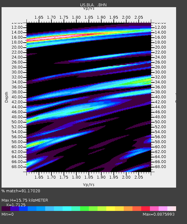
| Estimated Moho Depth: |
15.75 km |
| Estimated Crust Vp/Vs: |
1.71 |
| Assumed Crust Vp: |
6.159 km/s |
| Estimated Crust Vs: |
3.596 km/s |
| Estimated Crust Poisson's Ratio: |
0.24 |
|
| Radial Match: |
91.17028 % |
| Radial Bump: |
382 |
| Transverse Match: |
70.6168 % |
| Transverse Bump: |
400 |
| SOD ConfigId: |
2475 |
| Insert Time: |
2010-03-05 01:34:02.311 +0000 |
| GWidth: |
2.5 |
| Max Bumps: |
400 |
| Tol: |
0.001 |
|
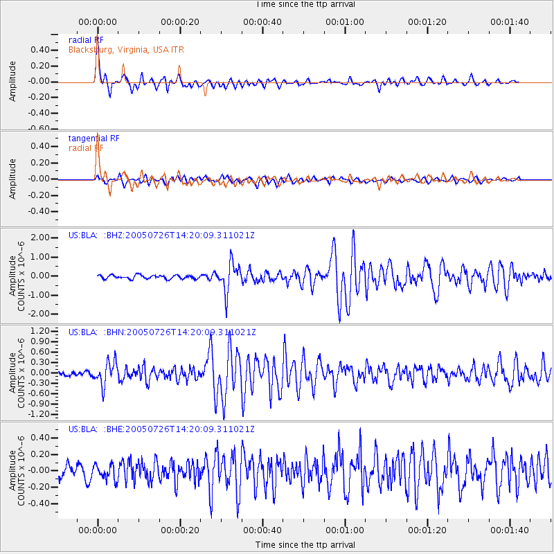
Signal To Noise
| Channel | StoN | STA | LTA |
| US:BLA: :BHN:20050726T14:20:09.311021Z | 6.1876683 | 3.3787728E-7 | 5.4604946E-8 |
| US:BLA: :BHE:20050726T14:20:09.311021Z | 1.3954041 | 9.109286E-8 | 6.528063E-8 |
| US:BLA: :BHZ:20050726T14:20:09.311021Z | 7.862958 | 7.580773E-7 | 9.641121E-8 |
| Arrivals |
| Ps | 1.9 SECOND |
| PpPs | 6.6 SECOND |
| PsPs/PpSs | 8.5 SECOND |


