You are here: Home > Network List > NM - Cooperative New Madrid Seismic Network Stations List
> Station UTMT Martin, TN > Earthquake Result Viewer
UTMT Martin, TN - Earthquake Result Viewer
| Earthquake location: |
Southern Alaska |
| Earthquake latitude/longitude: |
59.9/-153.1 |
| Earthquake time(UTC): |
2015/07/29 (210) 02:35:58 GMT |
| Earthquake Depth: |
118 km |
| Earthquake Magnitude: |
6.3 ML, 6.2 MWP, 6.2 MI, 6.3 MWW |
| Earthquake Catalog/Contributor: |
NEIC PDE/NEIC COMCAT |
|
| Network: |
NM Cooperative New Madrid Seismic Network |
| Station: |
UTMT Martin, TN |
| Lat/Lon: |
36.35 N/88.86 W |
| Elevation: |
110 m |
|
| Distance: |
46.6 deg |
| Az: |
90.465 deg |
| Baz: |
321.364 deg |
| Ray Param: |
0.07010619 |
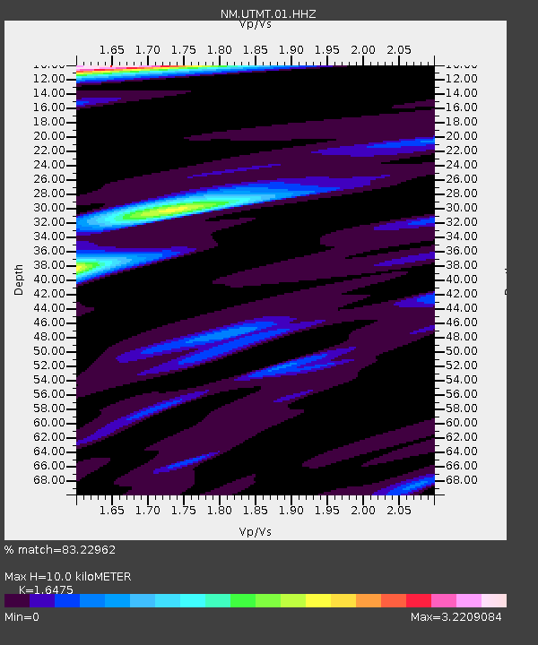
| Estimated Moho Depth: |
10.0 km |
| Estimated Crust Vp/Vs: |
1.65 |
| Assumed Crust Vp: |
6.444 km/s |
| Estimated Crust Vs: |
3.911 km/s |
| Estimated Crust Poisson's Ratio: |
0.21 |
|
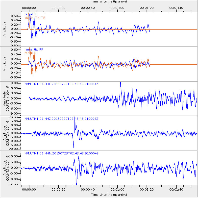
| Radial Match: |
83.22962 % |
| Radial Bump: |
400 |
| Transverse Match: |
69.3421 % |
| Transverse Bump: |
368 |
| SOD ConfigId: |
1085051 |
| Insert Time: |
2015-08-12 03:05:44.415 +0000 |
| GWidth: |
2.5 |
| Max Bumps: |
400 |
| Tol: |
0.001 |
|
Signal To Noise
| Channel | StoN | STA | LTA |
| NM:UTMT:01:HHZ:20150729T02:43:43.910004Z | 6.88799 | 1.2058536E-6 | 1.750661E-7 |
| NM:UTMT:01:HHN:20150729T02:43:43.910004Z | 1.8385786 | 5.4992523E-7 | 2.9910348E-7 |
| NM:UTMT:01:HHE:20150729T02:43:43.910004Z | 1.1508502 | 5.4417865E-7 | 4.7284928E-7 |
| Arrivals |
| Ps | 1.1 SECOND |
| PpPs | 3.8 SECOND |
| PsPs/PpSs | 4.9 SECOND |


