You are here: Home > Network List > NM - Cooperative New Madrid Seismic Network Stations List
> Station EUAL Eutaw, AL > Earthquake Result Viewer
EUAL Eutaw, AL - Earthquake Result Viewer
| Earthquake location: |
Southern Alaska |
| Earthquake latitude/longitude: |
59.9/-153.1 |
| Earthquake time(UTC): |
2015/07/29 (210) 02:35:58 GMT |
| Earthquake Depth: |
118 km |
| Earthquake Magnitude: |
6.3 ML, 6.2 MWP, 6.2 MI, 6.3 MWW |
| Earthquake Catalog/Contributor: |
NEIC PDE/NEIC COMCAT |
|
| Network: |
NM Cooperative New Madrid Seismic Network |
| Station: |
EUAL Eutaw, AL |
| Lat/Lon: |
32.97 N/88.09 W |
| Elevation: |
76 m |
|
| Distance: |
49.7 deg |
| Az: |
92.552 deg |
| Baz: |
323.197 deg |
| Ray Param: |
0.06815249 |
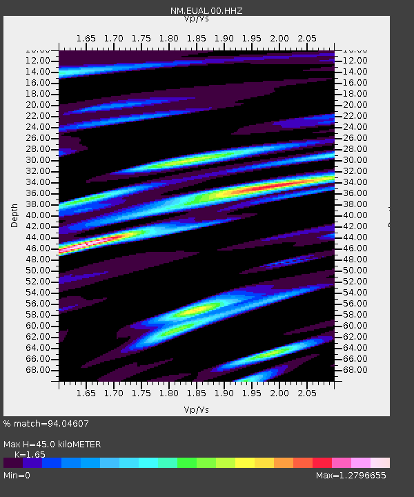
| Estimated Moho Depth: |
45.0 km |
| Estimated Crust Vp/Vs: |
1.65 |
| Assumed Crust Vp: |
6.201 km/s |
| Estimated Crust Vs: |
3.758 km/s |
| Estimated Crust Poisson's Ratio: |
0.21 |
|
| Radial Match: |
94.04607 % |
| Radial Bump: |
349 |
| Transverse Match: |
90.60566 % |
| Transverse Bump: |
381 |
| SOD ConfigId: |
1085051 |
| Insert Time: |
2015-08-12 03:05:54.026 +0000 |
| GWidth: |
2.5 |
| Max Bumps: |
400 |
| Tol: |
0.001 |
|

Signal To Noise
| Channel | StoN | STA | LTA |
| NM:EUAL:00:HHZ:20150729T02:44:07.359985Z | 6.7120643 | 7.2364617E-7 | 1.0781276E-7 |
| NM:EUAL:00:HHN:20150729T02:44:07.359985Z | 1.1151344 | 2.0826505E-7 | 1.867623E-7 |
| NM:EUAL:00:HHE:20150729T02:44:07.359985Z | 1.1596035 | 2.748703E-7 | 2.3703817E-7 |
| Arrivals |
| Ps | 5.0 SECOND |
| PpPs | 18 SECOND |
| PsPs/PpSs | 23 SECOND |


