You are here: Home > Network List > TA - USArray Transportable Network (new EarthScope stations) Stations List
> Station G03D McMinnville, OR, USA > Earthquake Result Viewer
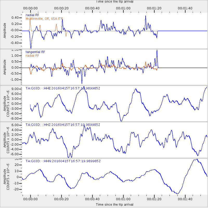
G03D McMinnville, OR, USA - Earthquake Result Viewer
*The percent match for this event was below the threshold and hence no stack was calculated.
| Earthquake location: |
Kyushu, Japan |
| Earthquake latitude/longitude: |
32.9/130.8 |
| Earthquake time(UTC): |
2016/04/15 (106) 16:45:56 GMT |
| Earthquake Depth: |
10 km |
| Earthquake Magnitude: |
5.7 MB |
| Earthquake Catalog/Contributor: |
NEIC PDE/NEIC COMCAT |
|
| Network: |
TA USArray Transportable Network (new EarthScope stations) |
| Station: |
G03D McMinnville, OR, USA |
| Lat/Lon: |
45.21 N/123.26 W |
| Elevation: |
222 m |
|
| Distance: |
77.3 deg |
| Az: |
44.173 deg |
| Baz: |
303.952 deg |
| Ray Param: |
$rayparam |
*The percent match for this event was below the threshold and hence was not used in the summary stack. |
|
| Radial Match: |
52.347313 % |
| Radial Bump: |
268 |
| Transverse Match: |
52.15921 % |
| Transverse Bump: |
312 |
| SOD ConfigId: |
7422571 |
| Insert Time: |
2019-04-22 07:25:51.706 +0000 |
| GWidth: |
2.5 |
| Max Bumps: |
400 |
| Tol: |
0.001 |
|
Signal To Noise
| Channel | StoN | STA | LTA |
| TA:G03D: :HHZ:20160415T16:57:19.989985Z | 1.5444603 | 2.0990344E-6 | 1.359073E-6 |
| TA:G03D: :HHN:20160415T16:57:19.989985Z | 2.4996972 | 9.229464E-6 | 3.692233E-6 |
| TA:G03D: :HHE:20160415T16:57:19.989985Z | 2.6611283 | 8.65027E-6 | 3.2506023E-6 |
| Arrivals |
| Ps | |
| PpPs | |
| PsPs/PpSs | |


