You are here: Home > Network List > US - United States National Seismic Network Stations List
> Station BLA Blacksburg, Virginia, USA > Earthquake Result Viewer
BLA Blacksburg, Virginia, USA - Earthquake Result Viewer
| Earthquake location: |
Near West Coast Of Colombia |
| Earthquake latitude/longitude: |
3.0/-78.0 |
| Earthquake time(UTC): |
2007/09/10 (253) 01:49:14 GMT |
| Earthquake Depth: |
31 km |
| Earthquake Magnitude: |
6.1 MB, 6.7 MS, 6.8 MW |
| Earthquake Catalog/Contributor: |
WHDF/NEIC |
|
| Network: |
US United States National Seismic Network |
| Station: |
BLA Blacksburg, Virginia, USA |
| Lat/Lon: |
37.21 N/80.42 W |
| Elevation: |
634 m |
|
| Distance: |
34.1 deg |
| Az: |
356.508 deg |
| Baz: |
175.63 deg |
| Ray Param: |
0.07783685 |
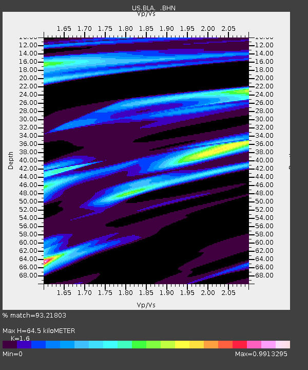
| Estimated Moho Depth: |
64.5 km |
| Estimated Crust Vp/Vs: |
1.60 |
| Assumed Crust Vp: |
6.159 km/s |
| Estimated Crust Vs: |
3.849 km/s |
| Estimated Crust Poisson's Ratio: |
0.18 |
|
| Radial Match: |
93.21803 % |
| Radial Bump: |
325 |
| Transverse Match: |
75.12308 % |
| Transverse Bump: |
400 |
| SOD ConfigId: |
2564 |
| Insert Time: |
2010-03-05 01:34:18.389 +0000 |
| GWidth: |
2.5 |
| Max Bumps: |
400 |
| Tol: |
0.001 |
|
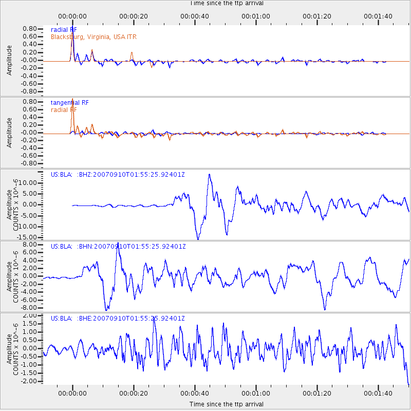
Signal To Noise
| Channel | StoN | STA | LTA |
| US:BLA: :BHN:20070910T01:55:25.92401Z | 9.160808 | 1.334683E-6 | 1.4569491E-7 |
| US:BLA: :BHE:20070910T01:55:25.92401Z | 2.2074695 | 3.4417909E-7 | 1.5591567E-7 |
| US:BLA: :BHZ:20070910T01:55:25.92401Z | 7.189589 | 1.9685913E-6 | 2.7381137E-7 |
| Arrivals |
| Ps | 6.8 SECOND |
| PpPs | 25 SECOND |
| PsPs/PpSs | 32 SECOND |


