You are here: Home > Network List > TA - USArray Transportable Network (new EarthScope stations) Stations List
> Station J26L Joseph Creek, AK, USA > Earthquake Result Viewer
J26L Joseph Creek, AK, USA - Earthquake Result Viewer

| Earthquake location: |
Kyushu, Japan |
| Earthquake latitude/longitude: |
32.9/130.8 |
| Earthquake time(UTC): |
2016/04/15 (106) 16:45:56 GMT |
| Earthquake Depth: |
10 km |
| Earthquake Magnitude: |
5.7 MB |
| Earthquake Catalog/Contributor: |
NEIC PDE/NEIC COMCAT |
|
| Network: |
TA USArray Transportable Network (new EarthScope stations) |
| Station: |
J26L Joseph Creek, AK, USA |
| Lat/Lon: |
64.50 N/143.56 W |
| Elevation: |
1144 m |
|
| Distance: |
59.0 deg |
| Az: |
30.232 deg |
| Baz: |
281.818 deg |
| Ray Param: |
0.062480066 |
| Estimated Moho Depth: |
15.5 km |
| Estimated Crust Vp/Vs: |
1.61 |
| Assumed Crust Vp: |
6.566 km/s |
| Estimated Crust Vs: |
4.078 km/s |
| Estimated Crust Poisson's Ratio: |
0.19 |
|
| Radial Match: |
90.498314 % |
| Radial Bump: |
327 |
| Transverse Match: |
57.949005 % |
| Transverse Bump: |
373 |
| SOD ConfigId: |
7422571 |
| Insert Time: |
2019-04-22 07:26:03.411 +0000 |
| GWidth: |
2.5 |
| Max Bumps: |
400 |
| Tol: |
0.001 |
|
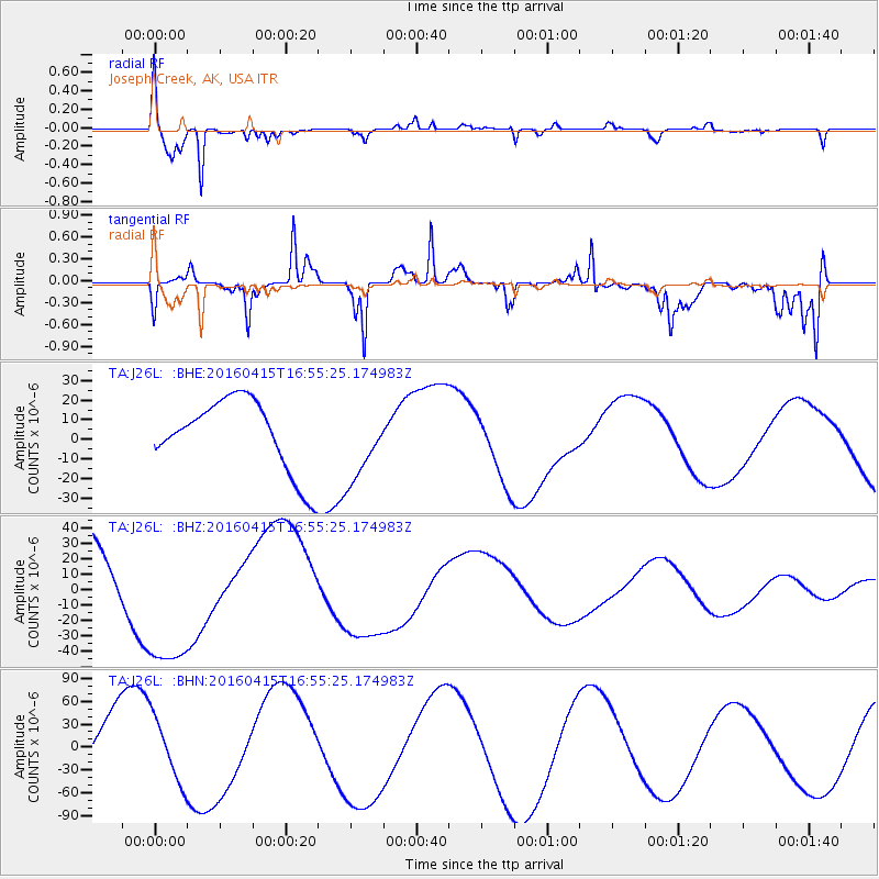
Signal To Noise
| Channel | StoN | STA | LTA |
| TA:J26L: :BHZ:20160415T16:55:25.174983Z | 1.7614936 | 5.1044226E-5 | 2.8977809E-5 |
| TA:J26L: :BHN:20160415T16:55:25.174983Z | 1.1983601 | 4.170349E-5 | 3.480047E-5 |
| TA:J26L: :BHE:20160415T16:55:25.174983Z | 0.9861978 | 1.8326959E-5 | 1.858345E-5 |
| Arrivals |
| Ps | 1.5 SECOND |
| PpPs | 5.8 SECOND |
| PsPs/PpSs | 7.4 SECOND |


