You are here: Home > Network List > TA - USArray Transportable Network (new EarthScope stations) Stations List
> Station M23K Glacier View, AK, USA > Earthquake Result Viewer
M23K Glacier View, AK, USA - Earthquake Result Viewer
| Earthquake location: |
Kyushu, Japan |
| Earthquake latitude/longitude: |
32.9/130.8 |
| Earthquake time(UTC): |
2016/04/15 (106) 16:45:56 GMT |
| Earthquake Depth: |
10 km |
| Earthquake Magnitude: |
5.7 MB |
| Earthquake Catalog/Contributor: |
NEIC PDE/NEIC COMCAT |
|
| Network: |
TA USArray Transportable Network (new EarthScope stations) |
| Station: |
M23K Glacier View, AK, USA |
| Lat/Lon: |
61.79 N/147.73 W |
| Elevation: |
583 m |
|
| Distance: |
57.7 deg |
| Az: |
33.787 deg |
| Baz: |
279.976 deg |
| Ray Param: |
0.06335307 |
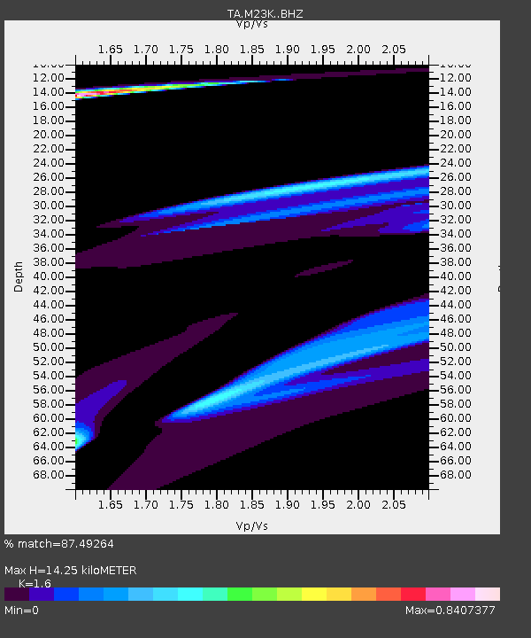
| Estimated Moho Depth: |
14.25 km |
| Estimated Crust Vp/Vs: |
1.60 |
| Assumed Crust Vp: |
6.566 km/s |
| Estimated Crust Vs: |
4.104 km/s |
| Estimated Crust Poisson's Ratio: |
0.18 |
|
| Radial Match: |
87.49264 % |
| Radial Bump: |
400 |
| Transverse Match: |
57.26699 % |
| Transverse Bump: |
400 |
| SOD ConfigId: |
7422571 |
| Insert Time: |
2019-04-22 07:26:08.217 +0000 |
| GWidth: |
2.5 |
| Max Bumps: |
400 |
| Tol: |
0.001 |
|

Signal To Noise
| Channel | StoN | STA | LTA |
| TA:M23K: :BHZ:20160415T16:55:15.825007Z | 2.185905 | 3.3874065E-5 | 1.5496586E-5 |
| TA:M23K: :BHN:20160415T16:55:15.825007Z | 0.48315996 | 1.4054813E-5 | 2.9089359E-5 |
| TA:M23K: :BHE:20160415T16:55:15.825007Z | 0.39629108 | 5.6545473E-6 | 1.4268672E-5 |
| Arrivals |
| Ps | 1.4 SECOND |
| PpPs | 5.3 SECOND |
| PsPs/PpSs | 6.7 SECOND |


