You are here: Home > Network List > TA - USArray Transportable Network (new EarthScope stations) Stations List
> Station O18K Koktuh Hills, AK, USA > Earthquake Result Viewer
O18K Koktuh Hills, AK, USA - Earthquake Result Viewer
| Earthquake location: |
Kyushu, Japan |
| Earthquake latitude/longitude: |
32.9/130.8 |
| Earthquake time(UTC): |
2016/04/15 (106) 16:45:56 GMT |
| Earthquake Depth: |
10 km |
| Earthquake Magnitude: |
5.7 MB |
| Earthquake Catalog/Contributor: |
NEIC PDE/NEIC COMCAT |
|
| Network: |
TA USArray Transportable Network (new EarthScope stations) |
| Station: |
O18K Koktuh Hills, AK, USA |
| Lat/Lon: |
59.85 N/155.21 W |
| Elevation: |
544 m |
|
| Distance: |
54.3 deg |
| Az: |
36.689 deg |
| Baz: |
275.076 deg |
| Ray Param: |
0.0655498 |
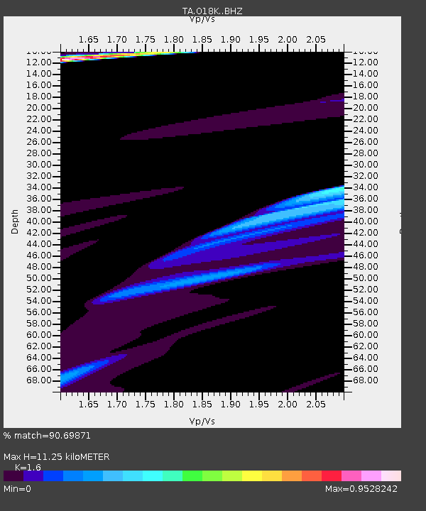
| Estimated Moho Depth: |
11.25 km |
| Estimated Crust Vp/Vs: |
1.60 |
| Assumed Crust Vp: |
6.438 km/s |
| Estimated Crust Vs: |
4.024 km/s |
| Estimated Crust Poisson's Ratio: |
0.18 |
|
| Radial Match: |
90.69871 % |
| Radial Bump: |
353 |
| Transverse Match: |
74.527115 % |
| Transverse Bump: |
180 |
| SOD ConfigId: |
7422571 |
| Insert Time: |
2019-04-22 07:26:13.219 +0000 |
| GWidth: |
2.5 |
| Max Bumps: |
400 |
| Tol: |
0.001 |
|
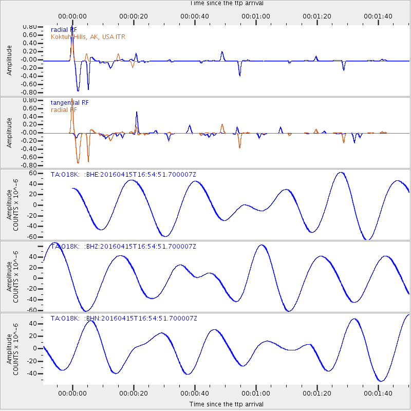
Signal To Noise
| Channel | StoN | STA | LTA |
| TA:O18K: :BHZ:20160415T16:54:51.700007Z | 0.888553 | 4.5139524E-5 | 5.0801158E-5 |
| TA:O18K: :BHN:20160415T16:54:51.700007Z | 2.1923664 | 2.2970606E-5 | 1.047754E-5 |
| TA:O18K: :BHE:20160415T16:54:51.700007Z | 1.6952717 | 5.3691252E-5 | 3.1671178E-5 |
| Arrivals |
| Ps | 1.1 SECOND |
| PpPs | 4.3 SECOND |
| PsPs/PpSs | 5.4 SECOND |


