You are here: Home > Network List > US - United States National Seismic Network Stations List
> Station BLA Blacksburg, Virginia, USA > Earthquake Result Viewer
BLA Blacksburg, Virginia, USA - Earthquake Result Viewer
| Earthquake location: |
Near Coast Of Peru |
| Earthquake latitude/longitude: |
-13.4/-76.6 |
| Earthquake time(UTC): |
2007/08/15 (227) 23:40:57 GMT |
| Earthquake Depth: |
39 km |
| Earthquake Magnitude: |
6.7 MB, 7.9 MS, 8.0 MW, 7.5 ME |
| Earthquake Catalog/Contributor: |
WHDF/NEIC |
|
| Network: |
US United States National Seismic Network |
| Station: |
BLA Blacksburg, Virginia, USA |
| Lat/Lon: |
37.21 N/80.42 W |
| Elevation: |
634 m |
|
| Distance: |
50.5 deg |
| Az: |
356.047 deg |
| Baz: |
175.179 deg |
| Ray Param: |
0.067959145 |
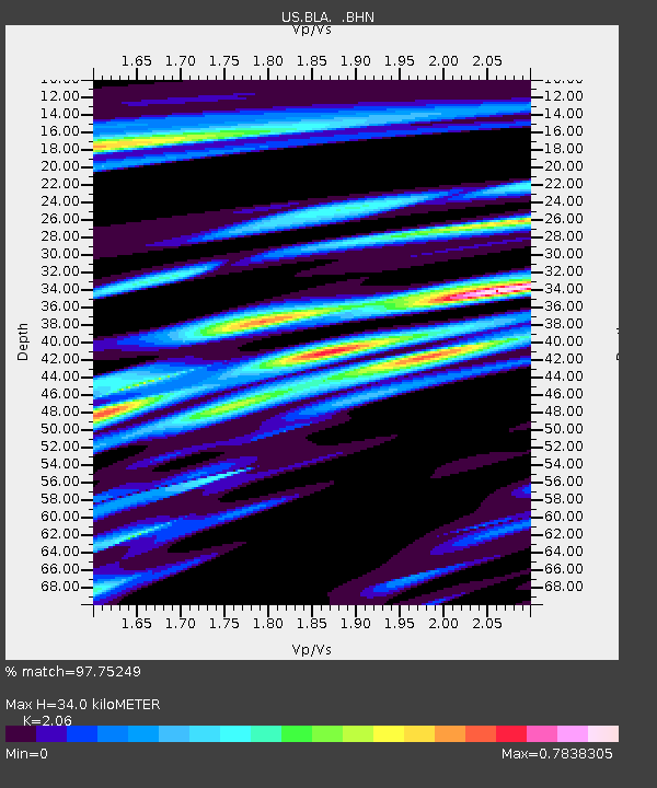
| Estimated Moho Depth: |
34.0 km |
| Estimated Crust Vp/Vs: |
2.06 |
| Assumed Crust Vp: |
6.159 km/s |
| Estimated Crust Vs: |
2.99 km/s |
| Estimated Crust Poisson's Ratio: |
0.35 |
|
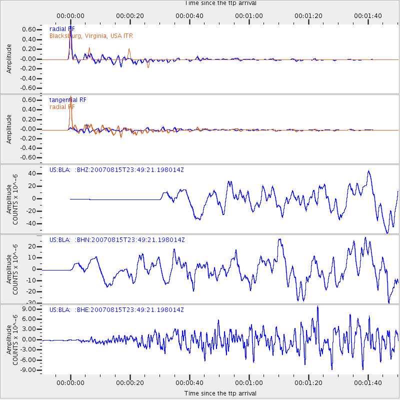
| Radial Match: |
97.75249 % |
| Radial Bump: |
400 |
| Transverse Match: |
82.00499 % |
| Transverse Bump: |
400 |
| SOD ConfigId: |
2564 |
| Insert Time: |
2010-03-05 01:34:27.388 +0000 |
| GWidth: |
2.5 |
| Max Bumps: |
400 |
| Tol: |
0.001 |
|
Signal To Noise
| Channel | StoN | STA | LTA |
| US:BLA: :BHN:20070815T23:49:21.198014Z | 19.71717 | 3.489667E-6 | 1.7698619E-7 |
| US:BLA: :BHE:20070815T23:49:21.198014Z | 2.8400936 | 1.7899066E-7 | 6.30228E-8 |
| US:BLA: :BHZ:20070815T23:49:21.198014Z | 18.025196 | 6.4056776E-6 | 3.5537354E-7 |
| Arrivals |
| Ps | 6.1 SECOND |
| PpPs | 16 SECOND |
| PsPs/PpSs | 22 SECOND |


