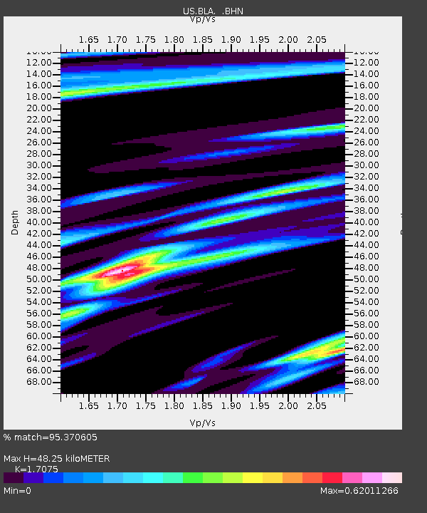
BLA Blacksburg, Virginia, USA - Earthquake Result Viewer
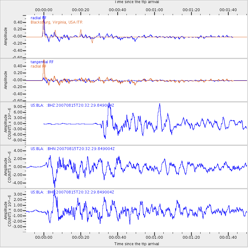
Earthquake location: Andreanof Islands, Aleutian Is.
Earthquake latitude/longitude: 50.3/-177.5
Earthquake time(UTC): 2007/08/15 (227) 20:22:11 GMT
Earthquake Depth: 9.0 km
Earthquake Magnitude: 6.3 MB, 6.2 MS, 6.4 MW, 5.9 ML
Earthquake Catalog/Contributor: WHDF/NEIC
Network: US United States National Seismic Network
Station: BLA Blacksburg, Virginia, USA
Lat/Lon: 37.21 N/80.42 W
Elevation: 634 m
Distance: 66.5 deg
Az: 59.748 deg
Baz: 316.087 deg
Ray Param: 0.05757579
Estimated Moho Depth: 48.25 km
Estimated Crust Vp/Vs: 1.71
Assumed Crust Vp: 6.159 km/s
Estimated Crust Vs: 3.607 km/s
Estimated Crust Poisson's Ratio: 0.24
Radial Match: 95.370605 %
Radial Bump: 400
Transverse Match: 87.52035 %
Transverse Bump: 400
SOD ConfigId: 2564
Insert Time: 2010-03-05 01:34:28.718 +0000
GWidth: 2.5
Max Bumps: 400
Tol: 0.001

Signal To Noise

ChannelStoNSTALTA
US:BLA: :BHN:20070815T20:32:29.849004Z6.5766641.2066248E-61.8347065E-7
US:BLA: :BHE:20070815T20:32:29.849004Z8.8518288.6826424E-79.80887E-8
US:BLA: :BHZ:20070815T20:32:29.849004Z27.2226963.2148016E-61.1809269E-7
Arrivals
Ps5.8 SECOND
PpPs20 SECOND
PsPs/PpSs26 SECOND