You are here: Home > Network List > US - United States National Seismic Network Stations List
> Station AGMN Agassiz National Wildlife Refuge, Minnesota, USA > Earthquake Result Viewer
AGMN Agassiz National Wildlife Refuge, Minnesota, USA - Earthquake Result Viewer
| Earthquake location: |
Southern Alaska |
| Earthquake latitude/longitude: |
59.9/-153.1 |
| Earthquake time(UTC): |
2015/07/29 (210) 02:35:58 GMT |
| Earthquake Depth: |
118 km |
| Earthquake Magnitude: |
6.3 ML, 6.2 MWP, 6.2 MI, 6.3 MWW |
| Earthquake Catalog/Contributor: |
NEIC PDE/NEIC COMCAT |
|
| Network: |
US United States National Seismic Network |
| Station: |
AGMN Agassiz National Wildlife Refuge, Minnesota, USA |
| Lat/Lon: |
48.30 N/95.86 W |
| Elevation: |
351 m |
|
| Distance: |
34.4 deg |
| Az: |
83.606 deg |
| Baz: |
311.392 deg |
| Ray Param: |
0.077383526 |
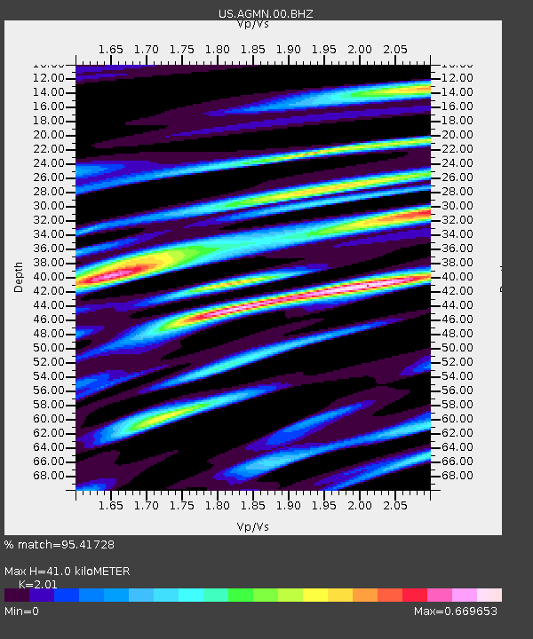
| Estimated Moho Depth: |
41.0 km |
| Estimated Crust Vp/Vs: |
2.01 |
| Assumed Crust Vp: |
6.419 km/s |
| Estimated Crust Vs: |
3.194 km/s |
| Estimated Crust Poisson's Ratio: |
0.34 |
|
| Radial Match: |
95.41728 % |
| Radial Bump: |
326 |
| Transverse Match: |
86.66817 % |
| Transverse Bump: |
400 |
| SOD ConfigId: |
1085051 |
| Insert Time: |
2015-08-12 03:06:59.574 +0000 |
| GWidth: |
2.5 |
| Max Bumps: |
400 |
| Tol: |
0.001 |
|
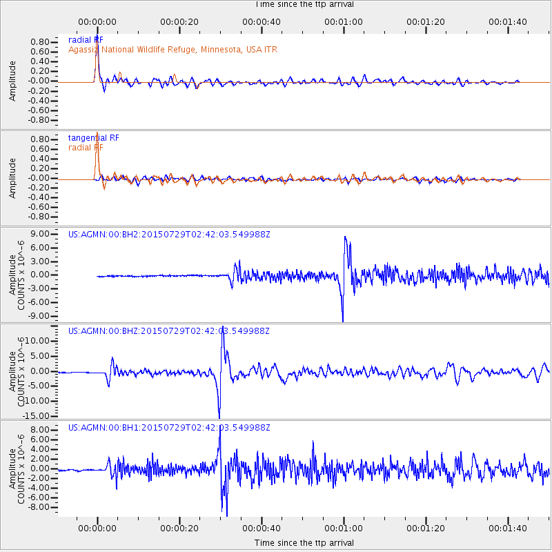
Signal To Noise
| Channel | StoN | STA | LTA |
| US:AGMN:00:BHZ:20150729T02:42:03.549988Z | 36.404976 | 2.0454738E-6 | 5.6186654E-8 |
| US:AGMN:00:BH1:20150729T02:42:03.549988Z | 12.232388 | 1.1725126E-6 | 9.585314E-8 |
| US:AGMN:00:BH2:20150729T02:42:03.549988Z | 14.334973 | 1.3072074E-6 | 9.119008E-8 |
| Arrivals |
| Ps | 6.9 SECOND |
| PpPs | 18 SECOND |
| PsPs/PpSs | 25 SECOND |


