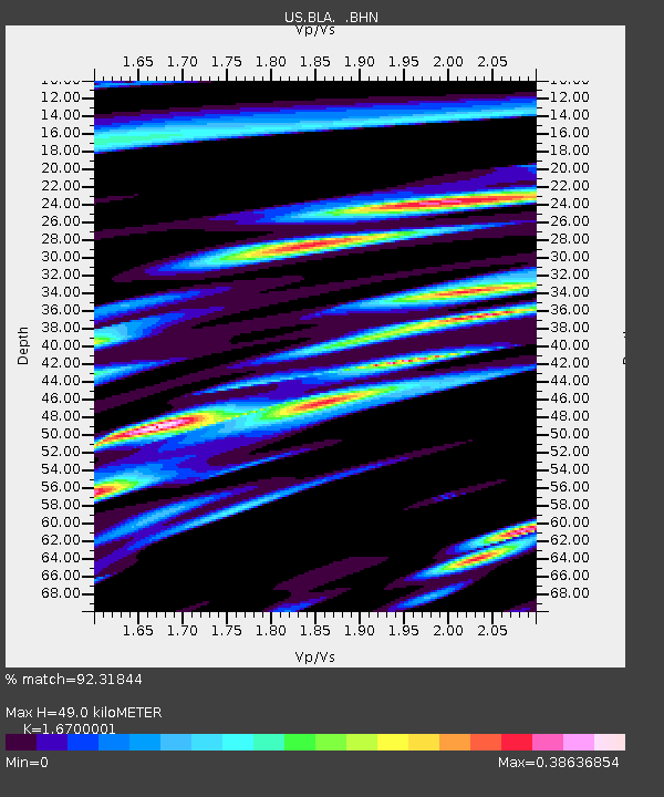
BLA Blacksburg, Virginia, USA - Earthquake Result Viewer
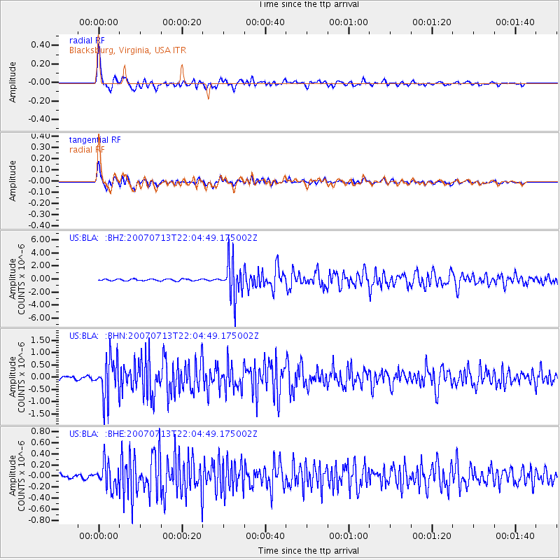
Earthquake location: Andreanof Islands, Aleutian Is.
Earthquake latitude/longitude: 51.8/-176.3
Earthquake time(UTC): 2007/07/13 (194) 21:54:43 GMT
Earthquake Depth: 35 km
Earthquake Magnitude: 5.7 MB, 5.6 MS, 6.0 MW, 5.9 MW
Earthquake Catalog/Contributor: WHDF/NEIC
Network: US United States National Seismic Network
Station: BLA Blacksburg, Virginia, USA
Lat/Lon: 37.21 N/80.42 W
Elevation: 634 m
Distance: 65.1 deg
Az: 61.149 deg
Baz: 317.102 deg
Ray Param: 0.05846289
Estimated Moho Depth: 49.0 km
Estimated Crust Vp/Vs: 1.67
Assumed Crust Vp: 6.159 km/s
Estimated Crust Vs: 3.688 km/s
Estimated Crust Poisson's Ratio: 0.22
Radial Match: 92.31844 %
Radial Bump: 400
Transverse Match: 87.795715 %
Transverse Bump: 400
SOD ConfigId: 2564
Insert Time: 2010-03-05 01:34:41.303 +0000
GWidth: 2.5
Max Bumps: 400
Tol: 0.001

Signal To Noise

ChannelStoNSTALTA
US:BLA: :BHN:20070713T22:04:49.175002Z10.36644658.071825E-77.786492E-8
US:BLA: :BHE:20070713T22:04:49.175002Z7.77503542.2284647E-72.8661795E-8
US:BLA: :BHZ:20070713T22:04:49.175002Z20.8129772.734722E-61.3139504E-7
Arrivals
Ps5.6 SECOND
PpPs20 SECOND
PsPs/PpSs26 SECOND