You are here: Home > Network List > US - United States National Seismic Network Stations List
> Station BLA Blacksburg, Virginia, USA > Earthquake Result Viewer
BLA Blacksburg, Virginia, USA - Earthquake Result Viewer
| Earthquake location: |
Kuril Islands |
| Earthquake latitude/longitude: |
46.0/151.4 |
| Earthquake time(UTC): |
2009/04/18 (108) 19:17:58 GMT |
| Earthquake Depth: |
35 km |
| Earthquake Magnitude: |
6.3 MB, 6.3 MS, 6.6 MW, 6.4 MW |
| Earthquake Catalog/Contributor: |
WHDF/NEIC |
|
| Network: |
US United States National Seismic Network |
| Station: |
BLA Blacksburg, Virginia, USA |
| Lat/Lon: |
37.21 N/80.42 W |
| Elevation: |
634 m |
|
| Distance: |
84.9 deg |
| Az: |
39.07 deg |
| Baz: |
326.622 deg |
| Ray Param: |
0.045073945 |
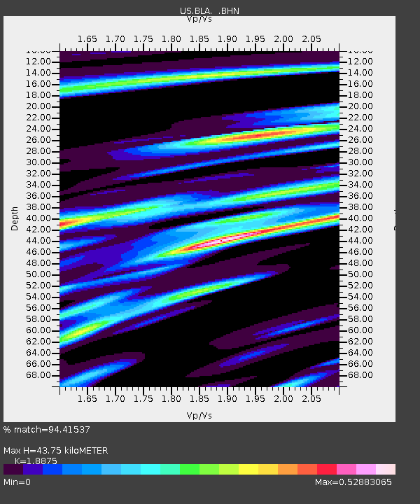
| Estimated Moho Depth: |
43.75 km |
| Estimated Crust Vp/Vs: |
1.89 |
| Assumed Crust Vp: |
6.159 km/s |
| Estimated Crust Vs: |
3.263 km/s |
| Estimated Crust Poisson's Ratio: |
0.30 |
|
| Radial Match: |
94.41537 % |
| Radial Bump: |
400 |
| Transverse Match: |
79.14013 % |
| Transverse Bump: |
400 |
| SOD ConfigId: |
2658 |
| Insert Time: |
2010-03-05 01:35:06.760 +0000 |
| GWidth: |
2.5 |
| Max Bumps: |
400 |
| Tol: |
0.001 |
|
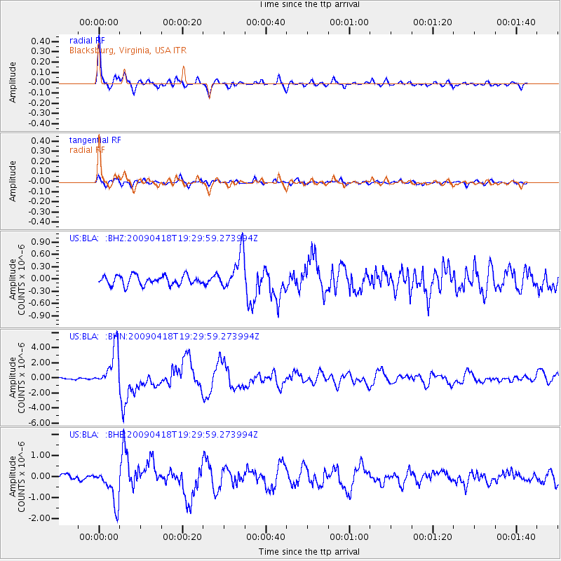
Signal To Noise
| Channel | StoN | STA | LTA |
| US:BLA: :BHN:20090418T19:29:59.273994Z | 24.399775 | 2.6404828E-6 | 1.08217506E-7 |
| US:BLA: :BHE:20090418T19:29:59.273994Z | 6.248565 | 8.6087397E-7 | 1.3777147E-7 |
| US:BLA: :BHZ:20090418T19:29:59.273994Z | 4.0146356 | 4.5716806E-7 | 1.1387536E-7 |
| Arrivals |
| Ps | 6.4 SECOND |
| PpPs | 20 SECOND |
| PsPs/PpSs | 27 SECOND |


