BLA Blacksburg, Virginia, USA - Earthquake Result Viewer
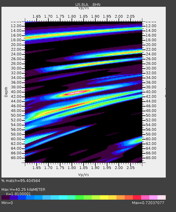
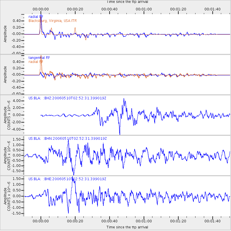
Earthquake location: Fox Islands, Aleutian Islands
Earthquake latitude/longitude: 52.5/-169.3
Earthquake time(UTC): 2006/05/10 (130) 02:42:51 GMT
Earthquake Depth: 18 km
Earthquake Magnitude: 6.1 MB, 6.2 MS, 6.4 MW, 6.3 MW
Earthquake Catalog/Contributor: WHDF/NEIC
Network: US United States National Seismic Network
Station: BLA Blacksburg, Virginia, USA
Lat/Lon: 37.21 N/80.42 W
Elevation: 634 m
Distance: 60.9 deg
Az: 66.013 deg
Baz: 315.624 deg
Ray Param: 0.061218742
Estimated Moho Depth: 40.25 km
Estimated Crust Vp/Vs: 1.81
Assumed Crust Vp: 6.159 km/s
Estimated Crust Vs: 3.403 km/s
Estimated Crust Poisson's Ratio: 0.28
Radial Match: 95.404564 %
Radial Bump: 400
Transverse Match: 77.72766 %
Transverse Bump: 400
SOD ConfigId: 2669
Insert Time: 2010-03-05 01:35:55.669 +0000
GWidth: 2.5
Max Bumps: 400
Tol: 0.001

Signal To Noise

ChannelStoNSTALTA
US:BLA: :BHN:20060510T02:52:31.399019Z2.88026743.7841946E-71.3138344E-7
US:BLA: :BHE:20060510T02:52:31.399019Z4.1445513.3555986E-78.0964114E-8
US:BLA: :BHZ:20060510T02:52:31.399019Z7.6169321.2167147E-61.5973816E-7
Arrivals
Ps5.5 SECOND
PpPs18 SECOND
PsPs/PpSs23 SECOND