You are here: Home > Network List > US - United States National Seismic Network Stations List
> Station BLA Blacksburg, Virginia, USA > Earthquake Result Viewer
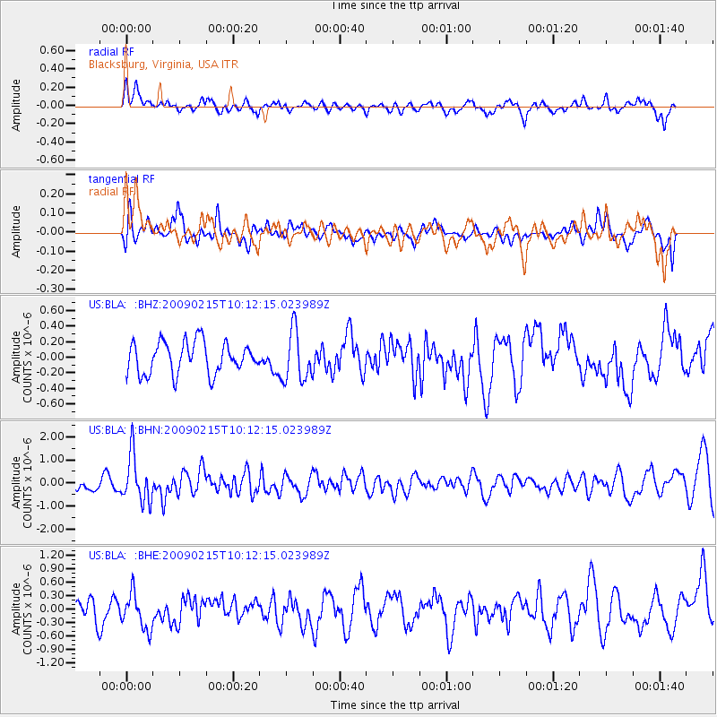
BLA Blacksburg, Virginia, USA - Earthquake Result Viewer
*The percent match for this event was below the threshold and hence no stack was calculated.
| Earthquake location: |
Near Coast Of Northern Peru |
| Earthquake latitude/longitude: |
-5.9/-80.9 |
| Earthquake time(UTC): |
2009/02/15 (046) 10:04:49 GMT |
| Earthquake Depth: |
21 km |
| Earthquake Magnitude: |
5.8 MB, 5.7 MS, 6.1 MW, 6.1 MW |
| Earthquake Catalog/Contributor: |
WHDF/NEIC |
|
| Network: |
US United States National Seismic Network |
| Station: |
BLA Blacksburg, Virginia, USA |
| Lat/Lon: |
37.21 N/80.42 W |
| Elevation: |
634 m |
|
| Distance: |
42.8 deg |
| Az: |
0.552 deg |
| Baz: |
180.688 deg |
| Ray Param: |
$rayparam |
*The percent match for this event was below the threshold and hence was not used in the summary stack. |
|
| Radial Match: |
58.926956 % |
| Radial Bump: |
400 |
| Transverse Match: |
41.814217 % |
| Transverse Bump: |
400 |
| SOD ConfigId: |
2658 |
| Insert Time: |
2010-03-05 01:36:22.428 +0000 |
| GWidth: |
2.5 |
| Max Bumps: |
400 |
| Tol: |
0.001 |
|
Signal To Noise
| Channel | StoN | STA | LTA |
| US:BLA: :BHN:20090215T10:12:15.023989Z | 3.309994 | 1.020253E-6 | 3.0823412E-7 |
| US:BLA: :BHE:20090215T10:12:15.023989Z | 1.4327633 | 4.0872465E-7 | 2.852702E-7 |
| US:BLA: :BHZ:20090215T10:12:15.023989Z | 1.6238534 | 3.2805497E-7 | 2.020225E-7 |
| Arrivals |
| Ps | |
| PpPs | |
| PsPs/PpSs | |


