You are here: Home > Network List > CI - Caltech Regional Seismic Network Stations List
> Station MPM Manuel Prospect Mine, California, USA > Earthquake Result Viewer
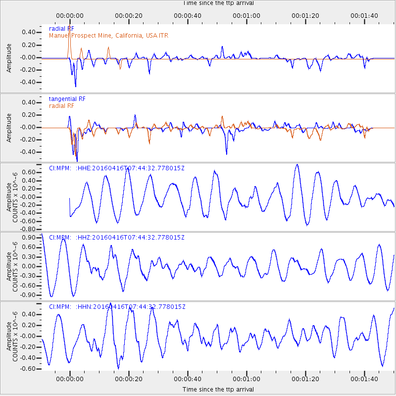
MPM Manuel Prospect Mine, California, USA - Earthquake Result Viewer
*The percent match for this event was below the threshold and hence no stack was calculated.
| Earthquake location: |
Easter Island Region |
| Earthquake latitude/longitude: |
-29.6/-111.6 |
| Earthquake time(UTC): |
2016/04/16 (107) 07:34:20 GMT |
| Earthquake Depth: |
10 km |
| Earthquake Magnitude: |
5.5 MWC, 5.5 MWC |
| Earthquake Catalog/Contributor: |
NEIC PDE/NEIC COMCAT |
|
| Network: |
CI Caltech Regional Seismic Network |
| Station: |
MPM Manuel Prospect Mine, California, USA |
| Lat/Lon: |
36.06 N/117.49 W |
| Elevation: |
185 m |
|
| Distance: |
65.5 deg |
| Az: |
354.736 deg |
| Baz: |
174.339 deg |
| Ray Param: |
$rayparam |
*The percent match for this event was below the threshold and hence was not used in the summary stack. |
|
| Radial Match: |
67.854034 % |
| Radial Bump: |
400 |
| Transverse Match: |
72.03886 % |
| Transverse Bump: |
400 |
| SOD ConfigId: |
7422571 |
| Insert Time: |
2019-04-22 07:48:20.187 +0000 |
| GWidth: |
2.5 |
| Max Bumps: |
400 |
| Tol: |
0.001 |
|
Signal To Noise
| Channel | StoN | STA | LTA |
| CI:MPM: :HHZ:20160416T07:44:32.778015Z | 0.95683 | 5.6651436E-7 | 5.920742E-7 |
| CI:MPM: :HHN:20160416T07:44:32.778015Z | 1.1148936 | 3.0849537E-7 | 2.767039E-7 |
| CI:MPM: :HHE:20160416T07:44:32.778015Z | 0.57974726 | 2.1473566E-7 | 3.7039533E-7 |
| Arrivals |
| Ps | |
| PpPs | |
| PsPs/PpSs | |


