You are here: Home > Network List > TA - USArray Transportable Network (new EarthScope stations) Stations List
> Station Z41A Richland Creek Farm, El Dorado, AR, USA > Earthquake Result Viewer
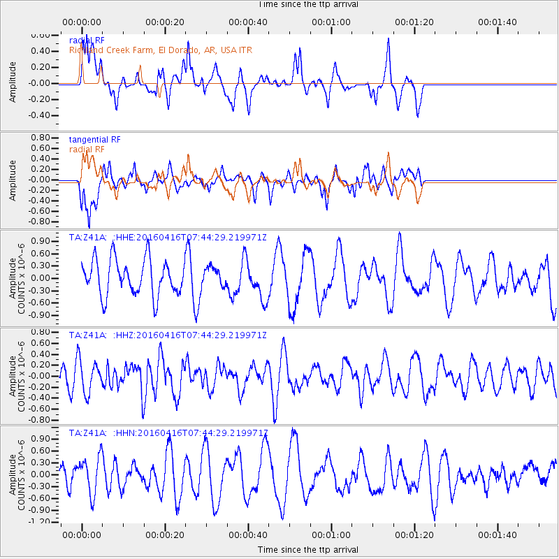
Z41A Richland Creek Farm, El Dorado, AR, USA - Earthquake Result Viewer
*The percent match for this event was below the threshold and hence no stack was calculated.
| Earthquake location: |
Easter Island Region |
| Earthquake latitude/longitude: |
-29.6/-111.6 |
| Earthquake time(UTC): |
2016/04/16 (107) 07:34:20 GMT |
| Earthquake Depth: |
10 km |
| Earthquake Magnitude: |
5.5 MWC, 5.5 MWC |
| Earthquake Catalog/Contributor: |
NEIC PDE/NEIC COMCAT |
|
| Network: |
TA USArray Transportable Network (new EarthScope stations) |
| Station: |
Z41A Richland Creek Farm, El Dorado, AR, USA |
| Lat/Lon: |
33.26 N/92.80 W |
| Elevation: |
62 m |
|
| Distance: |
65.0 deg |
| Az: |
17.311 deg |
| Baz: |
198.021 deg |
| Ray Param: |
$rayparam |
*The percent match for this event was below the threshold and hence was not used in the summary stack. |
|
| Radial Match: |
59.46263 % |
| Radial Bump: |
400 |
| Transverse Match: |
63.979977 % |
| Transverse Bump: |
400 |
| SOD ConfigId: |
7422571 |
| Insert Time: |
2019-04-22 07:53:01.802 +0000 |
| GWidth: |
2.5 |
| Max Bumps: |
400 |
| Tol: |
0.001 |
|
Signal To Noise
| Channel | StoN | STA | LTA |
| TA:Z41A: :HHZ:20160416T07:44:29.219971Z | 2.0285997 | 3.0468135E-7 | 1.5019293E-7 |
| TA:Z41A: :HHN:20160416T07:44:29.219971Z | 1.9033532 | 4.7973896E-7 | 2.5204935E-7 |
| TA:Z41A: :HHE:20160416T07:44:29.219971Z | 0.49186283 | 2.1270091E-7 | 4.3243946E-7 |
| Arrivals |
| Ps | |
| PpPs | |
| PsPs/PpSs | |


