You are here: Home > Network List > US - United States National Seismic Network Stations List
> Station WMOK Wichita Mountains, Oklahoma, USA > Earthquake Result Viewer
WMOK Wichita Mountains, Oklahoma, USA - Earthquake Result Viewer
| Earthquake location: |
Southern Alaska |
| Earthquake latitude/longitude: |
59.9/-153.1 |
| Earthquake time(UTC): |
2015/07/29 (210) 02:35:58 GMT |
| Earthquake Depth: |
118 km |
| Earthquake Magnitude: |
6.3 ML, 6.2 MWP, 6.2 MI, 6.3 MWW |
| Earthquake Catalog/Contributor: |
NEIC PDE/NEIC COMCAT |
|
| Network: |
US United States National Seismic Network |
| Station: |
WMOK Wichita Mountains, Oklahoma, USA |
| Lat/Lon: |
34.74 N/98.78 W |
| Elevation: |
486 m |
|
| Distance: |
42.9 deg |
| Az: |
100.936 deg |
| Baz: |
323.061 deg |
| Ray Param: |
0.072450906 |
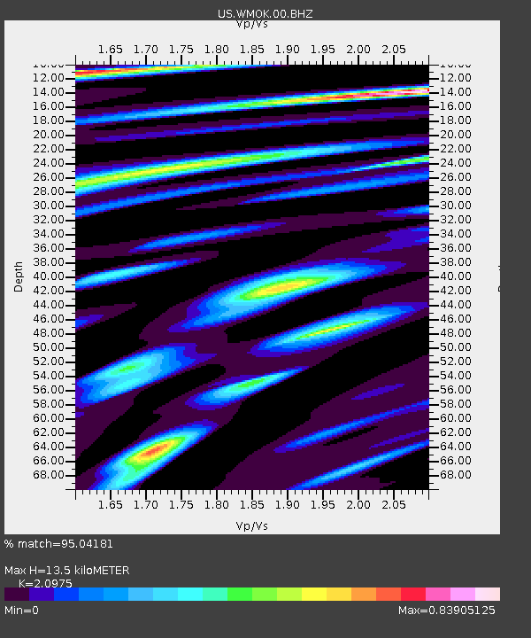
| Estimated Moho Depth: |
13.5 km |
| Estimated Crust Vp/Vs: |
2.10 |
| Assumed Crust Vp: |
6.315 km/s |
| Estimated Crust Vs: |
3.011 km/s |
| Estimated Crust Poisson's Ratio: |
0.35 |
|
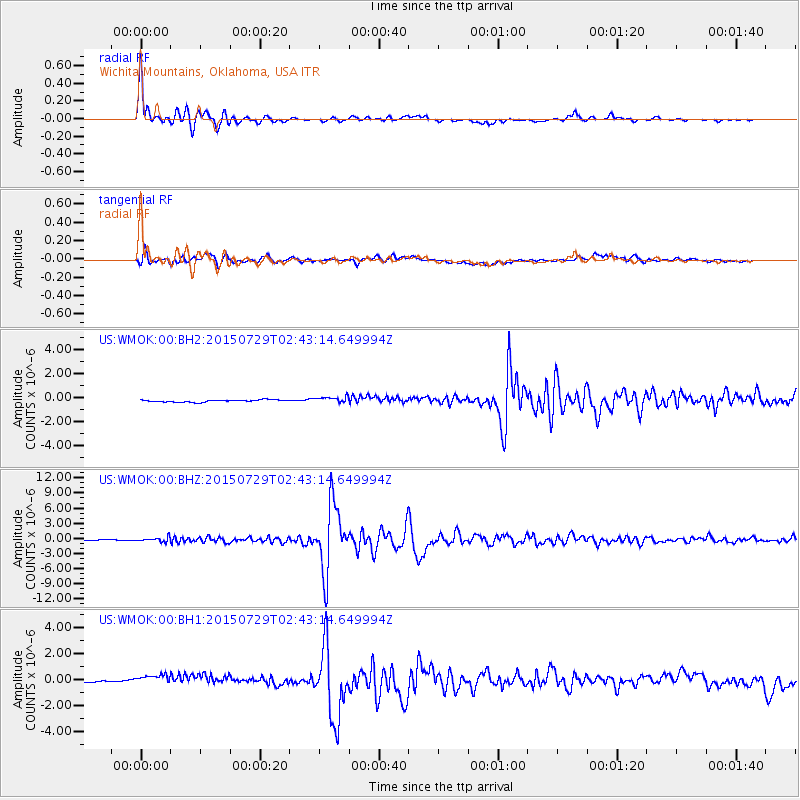
| Radial Match: |
95.04181 % |
| Radial Bump: |
306 |
| Transverse Match: |
67.59779 % |
| Transverse Bump: |
400 |
| SOD ConfigId: |
1085051 |
| Insert Time: |
2015-08-12 03:09:19.227 +0000 |
| GWidth: |
2.5 |
| Max Bumps: |
400 |
| Tol: |
0.001 |
|
Signal To Noise
| Channel | StoN | STA | LTA |
| US:WMOK:00:BHZ:20150729T02:43:14.649994Z | 4.5915346 | 4.2279976E-7 | 9.208245E-8 |
| US:WMOK:00:BH1:20150729T02:43:14.649994Z | 2.5967762 | 6.25097E-7 | 2.407204E-7 |
| US:WMOK:00:BH2:20150729T02:43:14.649994Z | 3.1649184 | 2.7399147E-7 | 8.657142E-8 |
| Arrivals |
| Ps | 2.5 SECOND |
| PpPs | 6.3 SECOND |
| PsPs/PpSs | 8.8 SECOND |


