You are here: Home > Network List > US - United States National Seismic Network Stations List
> Station WUAZ Wupatki, Arizona, USA > Earthquake Result Viewer
WUAZ Wupatki, Arizona, USA - Earthquake Result Viewer
| Earthquake location: |
Southern Alaska |
| Earthquake latitude/longitude: |
59.9/-153.1 |
| Earthquake time(UTC): |
2015/07/29 (210) 02:35:58 GMT |
| Earthquake Depth: |
118 km |
| Earthquake Magnitude: |
6.3 ML, 6.2 MWP, 6.2 MI, 6.3 MWW |
| Earthquake Catalog/Contributor: |
NEIC PDE/NEIC COMCAT |
|
| Network: |
US United States National Seismic Network |
| Station: |
WUAZ Wupatki, Arizona, USA |
| Lat/Lon: |
35.52 N/111.37 W |
| Elevation: |
1592 m |
|
| Distance: |
36.2 deg |
| Az: |
113.373 deg |
| Baz: |
325.445 deg |
| Ray Param: |
0.07639449 |
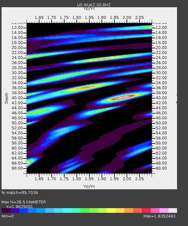
| Estimated Moho Depth: |
39.5 km |
| Estimated Crust Vp/Vs: |
1.98 |
| Assumed Crust Vp: |
6.207 km/s |
| Estimated Crust Vs: |
3.131 km/s |
| Estimated Crust Poisson's Ratio: |
0.33 |
|
| Radial Match: |
95.7036 % |
| Radial Bump: |
400 |
| Transverse Match: |
87.62119 % |
| Transverse Bump: |
400 |
| SOD ConfigId: |
1085051 |
| Insert Time: |
2015-08-12 03:09:23.900 +0000 |
| GWidth: |
2.5 |
| Max Bumps: |
400 |
| Tol: |
0.001 |
|

Signal To Noise
| Channel | StoN | STA | LTA |
| US:WUAZ:00:BHZ:20150729T02:42:19.324005Z | 2.8131952 | 1.7774116E-7 | 6.318124E-8 |
| US:WUAZ:00:BH1:20150729T02:42:19.324005Z | 1.2961512 | 1.1603908E-7 | 8.9525884E-8 |
| US:WUAZ:00:BH2:20150729T02:42:19.324005Z | 1.0514789 | 1.07802336E-7 | 1.0252449E-7 |
| Arrivals |
| Ps | 6.6 SECOND |
| PpPs | 18 SECOND |
| PsPs/PpSs | 25 SECOND |


