You are here: Home > Network List > 7A - Mid-Atlantic Geophysical Integrative Collaboration Stations List
> Station BDEG Charles Lake, Virginia USA > Earthquake Result Viewer
BDEG Charles Lake, Virginia USA - Earthquake Result Viewer
| Earthquake location: |
Near Coast Of Ecuador |
| Earthquake latitude/longitude: |
0.4/-79.9 |
| Earthquake time(UTC): |
2016/04/16 (107) 23:58:37 GMT |
| Earthquake Depth: |
19 km |
| Earthquake Magnitude: |
7.8 MWW, 7.4 MI |
| Earthquake Catalog/Contributor: |
NEIC PDE/NEIC COMCAT |
|
| Network: |
7A Mid-Atlantic Geophysical Integrative Collaboration |
| Station: |
BDEG Charles Lake, Virginia USA |
| Lat/Lon: |
37.33 N/77.21 W |
| Elevation: |
-21.0 m |
|
| Distance: |
36.9 deg |
| Az: |
3.63 deg |
| Baz: |
184.556 deg |
| Ray Param: |
0.07642635 |
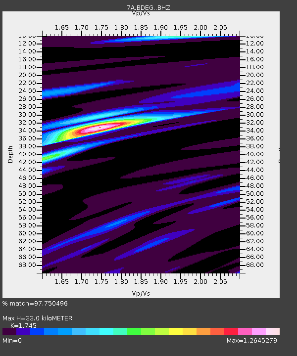
| Estimated Moho Depth: |
33.0 km |
| Estimated Crust Vp/Vs: |
1.75 |
| Assumed Crust Vp: |
6.565 km/s |
| Estimated Crust Vs: |
3.762 km/s |
| Estimated Crust Poisson's Ratio: |
0.26 |
|
| Radial Match: |
97.750496 % |
| Radial Bump: |
235 |
| Transverse Match: |
88.97357 % |
| Transverse Bump: |
400 |
| SOD ConfigId: |
7422571 |
| Insert Time: |
2019-04-22 07:55:47.587 +0000 |
| GWidth: |
2.5 |
| Max Bumps: |
400 |
| Tol: |
0.001 |
|

Signal To Noise
| Channel | StoN | STA | LTA |
| 7A:BDEG: :BHZ:20160417T00:05:13.035005Z | 41.448692 | 1.032466E-5 | 2.4909497E-7 |
| 7A:BDEG: :BHN:20160417T00:05:13.035005Z | 18.053968 | 6.5574554E-6 | 3.6321407E-7 |
| 7A:BDEG: :BHE:20160417T00:05:13.035005Z | 5.5353565 | 2.2588492E-6 | 4.0807654E-7 |
| Arrivals |
| Ps | 4.1 SECOND |
| PpPs | 13 SECOND |
| PsPs/PpSs | 17 SECOND |


