You are here: Home > Network List > 7A - Mid-Atlantic Geophysical Integrative Collaboration Stations List
> Station FOXP Brandywine, West Virginia USA > Earthquake Result Viewer
FOXP Brandywine, West Virginia USA - Earthquake Result Viewer
| Earthquake location: |
Near Coast Of Ecuador |
| Earthquake latitude/longitude: |
0.4/-79.9 |
| Earthquake time(UTC): |
2016/04/16 (107) 23:58:37 GMT |
| Earthquake Depth: |
19 km |
| Earthquake Magnitude: |
7.8 MWW, 7.4 MI |
| Earthquake Catalog/Contributor: |
NEIC PDE/NEIC COMCAT |
|
| Network: |
7A Mid-Atlantic Geophysical Integrative Collaboration |
| Station: |
FOXP Brandywine, West Virginia USA |
| Lat/Lon: |
38.63 N/79.25 W |
| Elevation: |
485 m |
|
| Distance: |
38.1 deg |
| Az: |
0.882 deg |
| Baz: |
181.126 deg |
| Ray Param: |
0.075747535 |
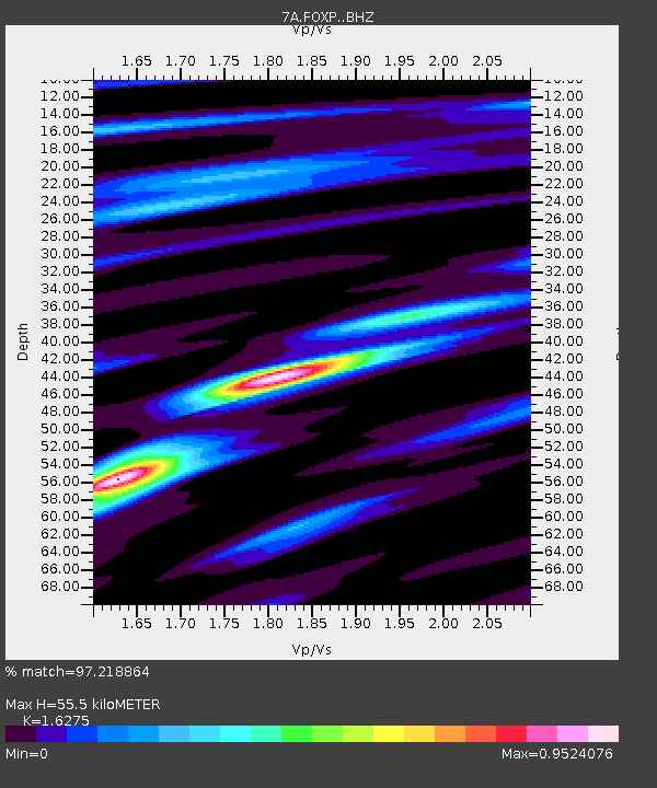
| Estimated Moho Depth: |
55.5 km |
| Estimated Crust Vp/Vs: |
1.63 |
| Assumed Crust Vp: |
6.159 km/s |
| Estimated Crust Vs: |
3.784 km/s |
| Estimated Crust Poisson's Ratio: |
0.20 |
|
| Radial Match: |
97.218864 % |
| Radial Bump: |
201 |
| Transverse Match: |
83.22999 % |
| Transverse Bump: |
400 |
| SOD ConfigId: |
7422571 |
| Insert Time: |
2019-04-22 07:55:52.397 +0000 |
| GWidth: |
2.5 |
| Max Bumps: |
400 |
| Tol: |
0.001 |
|

Signal To Noise
| Channel | StoN | STA | LTA |
| 7A:FOXP: :BHZ:20160417T00:05:23.295015Z | 40.65583 | 8.471617E-6 | 2.0837398E-7 |
| 7A:FOXP: :BHN:20160417T00:05:23.295015Z | 47.217266 | 5.309137E-6 | 1.1244059E-7 |
| 7A:FOXP: :BHE:20160417T00:05:23.295015Z | 1.6892086 | 2.768004E-7 | 1.6386394E-7 |
| Arrivals |
| Ps | 6.1 SECOND |
| PpPs | 22 SECOND |
| PsPs/PpSs | 28 SECOND |


