You are here: Home > Network List > 7A - Mid-Atlantic Geophysical Integrative Collaboration Stations List
> Station KENT Kenton, Ohio USA > Earthquake Result Viewer
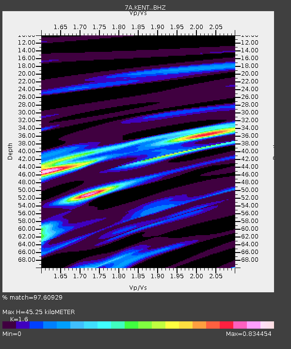
KENT Kenton, Ohio USA - Earthquake Result Viewer
| Earthquake location: |
Near Coast Of Ecuador |
| Earthquake latitude/longitude: |
0.4/-79.9 |
| Earthquake time(UTC): |
2016/04/16 (107) 23:58:37 GMT |
| Earthquake Depth: |
19 km |
| Earthquake Magnitude: |
7.8 MWW, 7.4 MI |
| Earthquake Catalog/Contributor: |
NEIC PDE/NEIC COMCAT |
|
| Network: |
7A Mid-Atlantic Geophysical Integrative Collaboration |
| Station: |
KENT Kenton, Ohio USA |
| Lat/Lon: |
40.63 N/83.64 W |
| Elevation: |
296 m |
|
| Distance: |
40.2 deg |
| Az: |
355.642 deg |
| Baz: |
174.27 deg |
| Ray Param: |
0.0745045 |
| Estimated Moho Depth: |
45.25 km |
| Estimated Crust Vp/Vs: |
1.60 |
| Assumed Crust Vp: |
6.498 km/s |
| Estimated Crust Vs: |
4.061 km/s |
| Estimated Crust Poisson's Ratio: |
0.18 |
|
| Radial Match: |
97.60929 % |
| Radial Bump: |
257 |
| Transverse Match: |
81.79116 % |
| Transverse Bump: |
400 |
| SOD ConfigId: |
7422571 |
| Insert Time: |
2019-04-22 07:55:53.687 +0000 |
| GWidth: |
2.5 |
| Max Bumps: |
400 |
| Tol: |
0.001 |
|

Signal To Noise
| Channel | StoN | STA | LTA |
| 7A:KENT: :BHZ:20160417T00:05:41.105012Z | 33.18561 | 7.5694466E-6 | 2.2809421E-7 |
| 7A:KENT: :BHN:20160417T00:05:41.105012Z | 29.745518 | 4.7596222E-6 | 1.6001141E-7 |
| 7A:KENT: :BHE:20160417T00:05:41.105012Z | 2.970332 | 4.4863245E-7 | 1.5103781E-7 |
| Arrivals |
| Ps | 4.5 SECOND |
| PpPs | 17 SECOND |
| PsPs/PpSs | 21 SECOND |


