You are here: Home > Network List > 7A - Mid-Atlantic Geophysical Integrative Collaboration Stations List
> Station LADY Linville, Virginia USA > Earthquake Result Viewer
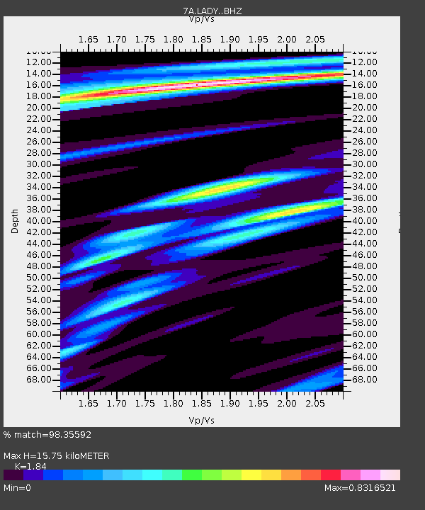
LADY Linville, Virginia USA - Earthquake Result Viewer
| Earthquake location: |
Near Coast Of Ecuador |
| Earthquake latitude/longitude: |
0.4/-79.9 |
| Earthquake time(UTC): |
2016/04/16 (107) 23:58:37 GMT |
| Earthquake Depth: |
19 km |
| Earthquake Magnitude: |
7.8 MWW, 7.4 MI |
| Earthquake Catalog/Contributor: |
NEIC PDE/NEIC COMCAT |
|
| Network: |
7A Mid-Atlantic Geophysical Integrative Collaboration |
| Station: |
LADY Linville, Virginia USA |
| Lat/Lon: |
38.51 N/78.76 W |
| Elevation: |
401 m |
|
| Distance: |
38.0 deg |
| Az: |
1.499 deg |
| Baz: |
181.911 deg |
| Ray Param: |
0.0758118 |
| Estimated Moho Depth: |
15.75 km |
| Estimated Crust Vp/Vs: |
1.84 |
| Assumed Crust Vp: |
6.159 km/s |
| Estimated Crust Vs: |
3.347 km/s |
| Estimated Crust Poisson's Ratio: |
0.29 |
|
| Radial Match: |
98.35592 % |
| Radial Bump: |
244 |
| Transverse Match: |
88.579475 % |
| Transverse Bump: |
400 |
| SOD ConfigId: |
7422571 |
| Insert Time: |
2019-04-22 07:55:53.906 +0000 |
| GWidth: |
2.5 |
| Max Bumps: |
400 |
| Tol: |
0.001 |
|

Signal To Noise
| Channel | StoN | STA | LTA |
| 7A:LADY: :BHZ:20160417T00:05:22.355012Z | 33.992218 | 9.598798E-6 | 2.8238222E-7 |
| 7A:LADY: :BHN:20160417T00:05:22.355012Z | 29.262508 | 6.0425928E-6 | 2.0649607E-7 |
| 7A:LADY: :BHE:20160417T00:05:22.355012Z | 3.1210465 | 4.453058E-7 | 1.4267836E-7 |
| Arrivals |
| Ps | 2.3 SECOND |
| PpPs | 6.8 SECOND |
| PsPs/PpSs | 9.1 SECOND |


