You are here: Home > Network List > 7A - Mid-Atlantic Geophysical Integrative Collaboration Stations List
> Station MOLE Hinton, Virginia USA > Earthquake Result Viewer
MOLE Hinton, Virginia USA - Earthquake Result Viewer
| Earthquake location: |
Near Coast Of Ecuador |
| Earthquake latitude/longitude: |
0.4/-79.9 |
| Earthquake time(UTC): |
2016/04/16 (107) 23:58:37 GMT |
| Earthquake Depth: |
19 km |
| Earthquake Magnitude: |
7.8 MWW, 7.4 MI |
| Earthquake Catalog/Contributor: |
NEIC PDE/NEIC COMCAT |
|
| Network: |
7A Mid-Atlantic Geophysical Integrative Collaboration |
| Station: |
MOLE Hinton, Virginia USA |
| Lat/Lon: |
38.49 N/79.02 W |
| Elevation: |
487 m |
|
| Distance: |
37.9 deg |
| Az: |
1.177 deg |
| Baz: |
181.5 deg |
| Ray Param: |
0.075823694 |
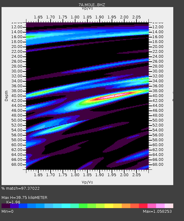
| Estimated Moho Depth: |
39.75 km |
| Estimated Crust Vp/Vs: |
1.96 |
| Assumed Crust Vp: |
6.159 km/s |
| Estimated Crust Vs: |
3.142 km/s |
| Estimated Crust Poisson's Ratio: |
0.32 |
|
| Radial Match: |
97.37022 % |
| Radial Bump: |
273 |
| Transverse Match: |
84.84073 % |
| Transverse Bump: |
400 |
| SOD ConfigId: |
7422571 |
| Insert Time: |
2019-04-22 07:55:56.037 +0000 |
| GWidth: |
2.5 |
| Max Bumps: |
400 |
| Tol: |
0.001 |
|

Signal To Noise
| Channel | StoN | STA | LTA |
| 7A:MOLE: :BHZ:20160417T00:05:22.195009Z | 43.946682 | 9.4447705E-6 | 2.1491431E-7 |
| 7A:MOLE: :BHN:20160417T00:05:22.195009Z | 30.049696 | 5.8467367E-6 | 1.9456893E-7 |
| 7A:MOLE: :BHE:20160417T00:05:22.195009Z | 2.8127294 | 6.0921224E-7 | 2.1659112E-7 |
| Arrivals |
| Ps | 6.6 SECOND |
| PpPs | 18 SECOND |
| PsPs/PpSs | 25 SECOND |


