You are here: Home > Network List > 7A - Mid-Atlantic Geophysical Integrative Collaboration Stations List
> Station RTSN Coon Bone Island, West Virginia USA > Earthquake Result Viewer
RTSN Coon Bone Island, West Virginia USA - Earthquake Result Viewer
| Earthquake location: |
Near Coast Of Ecuador |
| Earthquake latitude/longitude: |
0.4/-79.9 |
| Earthquake time(UTC): |
2016/04/16 (107) 23:58:37 GMT |
| Earthquake Depth: |
19 km |
| Earthquake Magnitude: |
7.8 MWW, 7.4 MI |
| Earthquake Catalog/Contributor: |
NEIC PDE/NEIC COMCAT |
|
| Network: |
7A Mid-Atlantic Geophysical Integrative Collaboration |
| Station: |
RTSN Coon Bone Island, West Virginia USA |
| Lat/Lon: |
38.94 N/79.58 W |
| Elevation: |
949 m |
|
| Distance: |
38.4 deg |
| Az: |
0.45 deg |
| Baz: |
180.577 deg |
| Ray Param: |
0.075567044 |
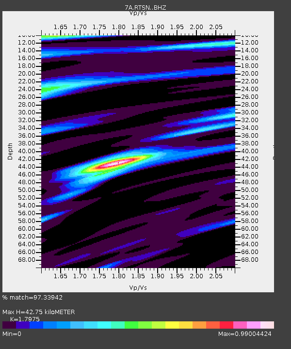
| Estimated Moho Depth: |
42.75 km |
| Estimated Crust Vp/Vs: |
1.80 |
| Assumed Crust Vp: |
6.159 km/s |
| Estimated Crust Vs: |
3.426 km/s |
| Estimated Crust Poisson's Ratio: |
0.28 |
|
| Radial Match: |
97.33942 % |
| Radial Bump: |
260 |
| Transverse Match: |
83.55454 % |
| Transverse Bump: |
400 |
| SOD ConfigId: |
7422571 |
| Insert Time: |
2019-04-22 07:55:59.867 +0000 |
| GWidth: |
2.5 |
| Max Bumps: |
400 |
| Tol: |
0.001 |
|

Signal To Noise
| Channel | StoN | STA | LTA |
| 7A:RTSN: :BHZ:20160417T00:05:25.929994Z | 32.907505 | 9.038807E-6 | 2.746731E-7 |
| 7A:RTSN: :BHN:20160417T00:05:25.929994Z | 28.340502 | 4.6118325E-6 | 1.6272939E-7 |
| 7A:RTSN: :BHE:20160417T00:05:25.929994Z | 2.0291767 | 3.3067658E-7 | 1.6296096E-7 |
| Arrivals |
| Ps | 5.9 SECOND |
| PpPs | 18 SECOND |
| PsPs/PpSs | 24 SECOND |


