You are here: Home > Network List > CI - Caltech Regional Seismic Network Stations List
> Station DEC Green Verdugo Microwave Site, Sunland, CA, USA > Earthquake Result Viewer
DEC Green Verdugo Microwave Site, Sunland, CA, USA - Earthquake Result Viewer
| Earthquake location: |
Rat Islands, Aleutian Islands |
| Earthquake latitude/longitude: |
51.8/177.1 |
| Earthquake time(UTC): |
2006/06/14 (165) 04:18:42 GMT |
| Earthquake Depth: |
14 km |
| Earthquake Magnitude: |
5.9 MB, 6.4 MS, 6.4 MW, 6.4 MW |
| Earthquake Catalog/Contributor: |
WHDF/NEIC |
|
| Network: |
CI Caltech Regional Seismic Network |
| Station: |
DEC Green Verdugo Microwave Site, Sunland, CA, USA |
| Lat/Lon: |
34.25 N/118.33 W |
| Elevation: |
519 m |
|
| Distance: |
48.7 deg |
| Az: |
84.669 deg |
| Baz: |
311.649 deg |
| Ray Param: |
0.06916903 |
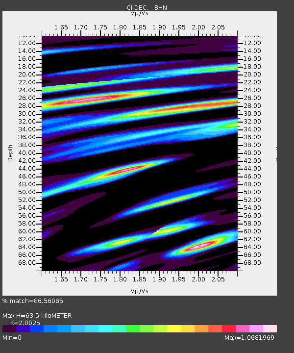
| Estimated Moho Depth: |
63.5 km |
| Estimated Crust Vp/Vs: |
2.00 |
| Assumed Crust Vp: |
6.1 km/s |
| Estimated Crust Vs: |
3.046 km/s |
| Estimated Crust Poisson's Ratio: |
0.33 |
|
| Radial Match: |
86.56065 % |
| Radial Bump: |
400 |
| Transverse Match: |
84.792076 % |
| Transverse Bump: |
400 |
| SOD ConfigId: |
5745 |
| Insert Time: |
2010-02-26 00:15:24.795 +0000 |
| GWidth: |
2.5 |
| Max Bumps: |
400 |
| Tol: |
0.001 |
|
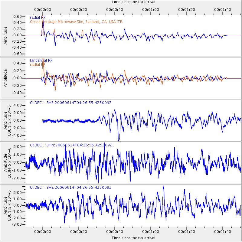
Signal To Noise
| Channel | StoN | STA | LTA |
| CI:DEC: :BHN:20060614T04:26:55.425009Z | 1.0413327 | 3.966384E-7 | 3.8089496E-7 |
| CI:DEC: :BHE:20060614T04:26:55.425009Z | 1.6479187 | 4.5412412E-7 | 2.7557434E-7 |
| CI:DEC: :BHZ:20060614T04:26:55.425009Z | 3.089465 | 6.578199E-7 | 2.1292357E-7 |
| Arrivals |
| Ps | 11 SECOND |
| PpPs | 30 SECOND |
| PsPs/PpSs | 41 SECOND |


