You are here: Home > Network List > AK - Alaska Regional Network Stations List
> Station COLD Coldfoot Broadband > Earthquake Result Viewer
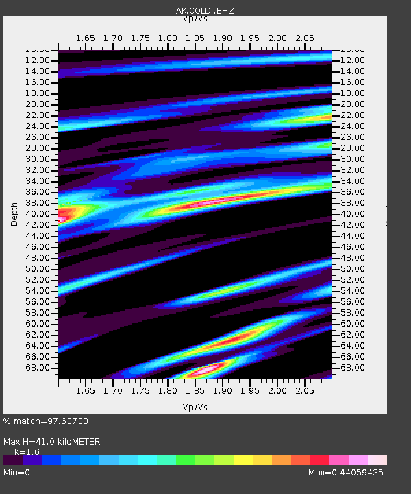
COLD Coldfoot Broadband - Earthquake Result Viewer
| Earthquake location: |
Near Coast Of Ecuador |
| Earthquake latitude/longitude: |
0.4/-79.9 |
| Earthquake time(UTC): |
2016/04/16 (107) 23:58:37 GMT |
| Earthquake Depth: |
19 km |
| Earthquake Magnitude: |
7.8 MWW, 7.4 MI |
| Earthquake Catalog/Contributor: |
NEIC PDE/NEIC COMCAT |
|
| Network: |
AK Alaska Regional Network |
| Station: |
COLD Coldfoot Broadband |
| Lat/Lon: |
67.23 N/150.20 W |
| Elevation: |
377 m |
|
| Distance: |
82.1 deg |
| Az: |
338.289 deg |
| Baz: |
108.151 deg |
| Ray Param: |
0.04710353 |
| Estimated Moho Depth: |
41.0 km |
| Estimated Crust Vp/Vs: |
1.60 |
| Assumed Crust Vp: |
6.577 km/s |
| Estimated Crust Vs: |
4.11 km/s |
| Estimated Crust Poisson's Ratio: |
0.18 |
|
| Radial Match: |
97.63738 % |
| Radial Bump: |
290 |
| Transverse Match: |
93.809525 % |
| Transverse Bump: |
400 |
| SOD ConfigId: |
7422571 |
| Insert Time: |
2019-04-22 07:56:37.684 +0000 |
| GWidth: |
2.5 |
| Max Bumps: |
400 |
| Tol: |
0.001 |
|

Signal To Noise
| Channel | StoN | STA | LTA |
| AK:COLD: :BHZ:20160417T00:10:24.527986Z | 39.92895 | 4.539907E-6 | 1.13699635E-7 |
| AK:COLD: :BHN:20160417T00:10:24.527986Z | 2.1593063 | 2.6861488E-7 | 1.243987E-7 |
| AK:COLD: :BHE:20160417T00:10:24.527986Z | 17.085272 | 1.538657E-6 | 9.0057505E-8 |
| Arrivals |
| Ps | 3.9 SECOND |
| PpPs | 16 SECOND |
| PsPs/PpSs | 20 SECOND |


