You are here: Home > Network List > AK - Alaska Regional Network Stations List
> Station LOGN Logan Glacier, AK, USA > Earthquake Result Viewer
LOGN Logan Glacier, AK, USA - Earthquake Result Viewer
| Earthquake location: |
Near Coast Of Ecuador |
| Earthquake latitude/longitude: |
0.4/-79.9 |
| Earthquake time(UTC): |
2016/04/16 (107) 23:58:37 GMT |
| Earthquake Depth: |
19 km |
| Earthquake Magnitude: |
7.8 MWW, 7.4 MI |
| Earthquake Catalog/Contributor: |
NEIC PDE/NEIC COMCAT |
|
| Network: |
AK Alaska Regional Network |
| Station: |
LOGN Logan Glacier, AK, USA |
| Lat/Lon: |
60.82 N/141.00 W |
| Elevation: |
1665 m |
|
| Distance: |
76.0 deg |
| Az: |
333.766 deg |
| Baz: |
115.562 deg |
| Ray Param: |
0.05130185 |
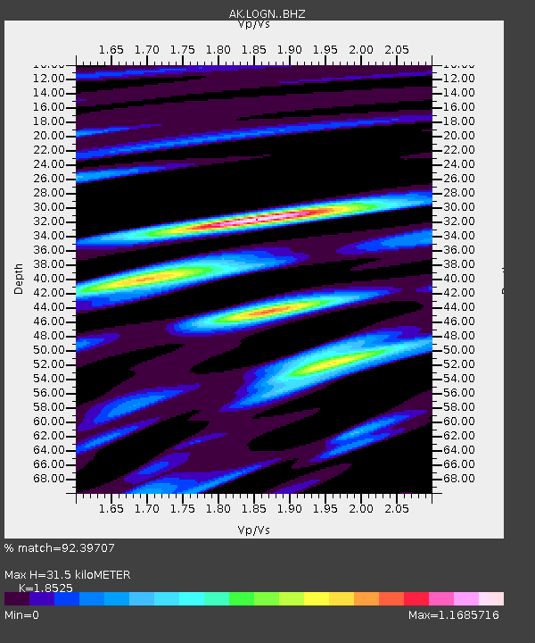
| Estimated Moho Depth: |
31.5 km |
| Estimated Crust Vp/Vs: |
1.85 |
| Assumed Crust Vp: |
6.566 km/s |
| Estimated Crust Vs: |
3.544 km/s |
| Estimated Crust Poisson's Ratio: |
0.29 |
|
| Radial Match: |
92.39707 % |
| Radial Bump: |
400 |
| Transverse Match: |
89.75932 % |
| Transverse Bump: |
400 |
| SOD ConfigId: |
7422571 |
| Insert Time: |
2019-04-22 07:57:03.784 +0000 |
| GWidth: |
2.5 |
| Max Bumps: |
400 |
| Tol: |
0.001 |
|

Signal To Noise
| Channel | StoN | STA | LTA |
| AK:LOGN: :BHZ:20160417T00:09:51.008027Z | 10.569477 | 3.1977086E-6 | 3.025418E-7 |
| AK:LOGN: :BHN:20160417T00:09:51.008027Z | 3.614665 | 6.462135E-7 | 1.7877548E-7 |
| AK:LOGN: :BHE:20160417T00:09:51.008027Z | 9.525667 | 1.0172312E-6 | 1.0678845E-7 |
| Arrivals |
| Ps | 4.2 SECOND |
| PpPs | 13 SECOND |
| PsPs/PpSs | 17 SECOND |


