You are here: Home > Network List > AK - Alaska Regional Network Stations List
> Station RIDG Independent Ridge > Earthquake Result Viewer
RIDG Independent Ridge - Earthquake Result Viewer
| Earthquake location: |
Near Coast Of Ecuador |
| Earthquake latitude/longitude: |
0.4/-79.9 |
| Earthquake time(UTC): |
2016/04/16 (107) 23:58:37 GMT |
| Earthquake Depth: |
19 km |
| Earthquake Magnitude: |
7.8 MWW, 7.4 MI |
| Earthquake Catalog/Contributor: |
NEIC PDE/NEIC COMCAT |
|
| Network: |
AK Alaska Regional Network |
| Station: |
RIDG Independent Ridge |
| Lat/Lon: |
63.74 N/144.84 W |
| Elevation: |
888 m |
|
| Distance: |
78.8 deg |
| Az: |
335.753 deg |
| Baz: |
112.604 deg |
| Ray Param: |
0.049387548 |
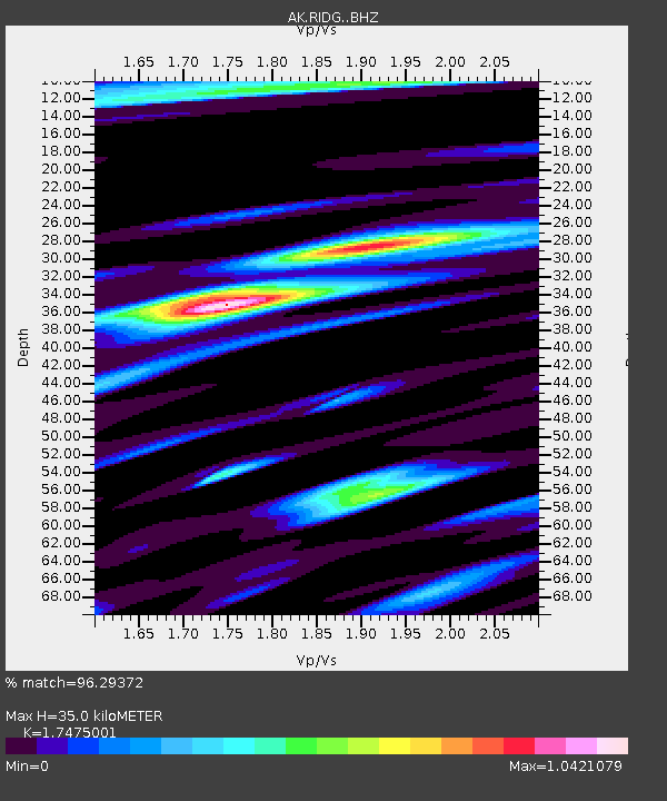
| Estimated Moho Depth: |
35.0 km |
| Estimated Crust Vp/Vs: |
1.75 |
| Assumed Crust Vp: |
6.566 km/s |
| Estimated Crust Vs: |
3.757 km/s |
| Estimated Crust Poisson's Ratio: |
0.26 |
|
| Radial Match: |
96.29372 % |
| Radial Bump: |
400 |
| Transverse Match: |
92.76614 % |
| Transverse Bump: |
400 |
| SOD ConfigId: |
7422571 |
| Insert Time: |
2019-04-22 07:57:16.083 +0000 |
| GWidth: |
2.5 |
| Max Bumps: |
400 |
| Tol: |
0.001 |
|

Signal To Noise
| Channel | StoN | STA | LTA |
| AK:RIDG: :BHZ:20160417T00:10:06.808015Z | 32.737797 | 5.0269887E-6 | 1.5355305E-7 |
| AK:RIDG: :BHN:20160417T00:10:06.808015Z | 3.0696592 | 5.4725666E-7 | 1.782793E-7 |
| AK:RIDG: :BHE:20160417T00:10:06.808015Z | 11.139135 | 1.8061959E-6 | 1.6214867E-7 |
| Arrivals |
| Ps | 4.1 SECOND |
| PpPs | 14 SECOND |
| PsPs/PpSs | 18 SECOND |


