You are here: Home > Network List > AK - Alaska Regional Network Stations List
> Station SAW Sawmill > Earthquake Result Viewer
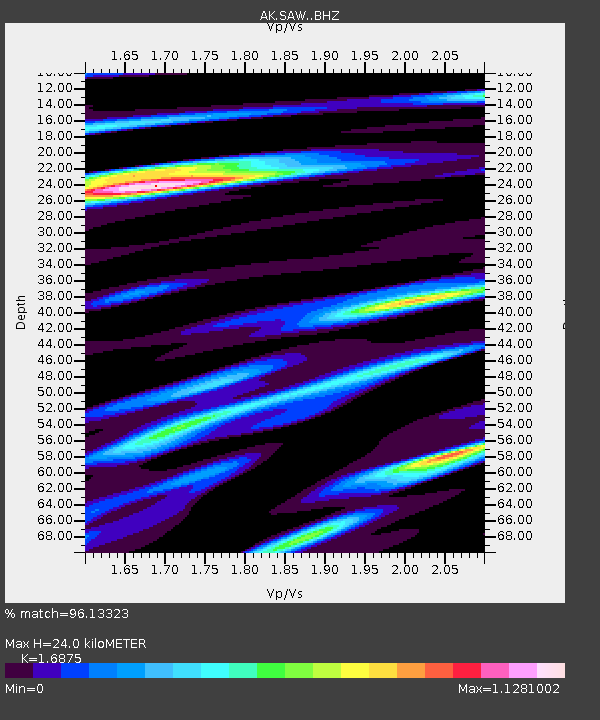
SAW Sawmill - Earthquake Result Viewer
| Earthquake location: |
Near Coast Of Ecuador |
| Earthquake latitude/longitude: |
0.4/-79.9 |
| Earthquake time(UTC): |
2016/04/16 (107) 23:58:37 GMT |
| Earthquake Depth: |
19 km |
| Earthquake Magnitude: |
7.8 MWW, 7.4 MI |
| Earthquake Catalog/Contributor: |
NEIC PDE/NEIC COMCAT |
|
| Network: |
AK Alaska Regional Network |
| Station: |
SAW Sawmill |
| Lat/Lon: |
61.81 N/148.33 W |
| Elevation: |
782 m |
|
| Distance: |
79.6 deg |
| Az: |
333.327 deg |
| Baz: |
109.051 deg |
| Ray Param: |
0.048834834 |
| Estimated Moho Depth: |
24.0 km |
| Estimated Crust Vp/Vs: |
1.69 |
| Assumed Crust Vp: |
6.566 km/s |
| Estimated Crust Vs: |
3.891 km/s |
| Estimated Crust Poisson's Ratio: |
0.23 |
|
| Radial Match: |
96.13323 % |
| Radial Bump: |
400 |
| Transverse Match: |
92.3569 % |
| Transverse Bump: |
400 |
| SOD ConfigId: |
7422571 |
| Insert Time: |
2019-04-22 07:57:19.353 +0000 |
| GWidth: |
2.5 |
| Max Bumps: |
400 |
| Tol: |
0.001 |
|

Signal To Noise
| Channel | StoN | STA | LTA |
| AK:SAW: :BHZ:20160417T00:10:11.227998Z | 31.886349 | 4.3493283E-6 | 1.3640096E-7 |
| AK:SAW: :BHN:20160417T00:10:11.227998Z | 2.812151 | 5.2244957E-7 | 1.8578291E-7 |
| AK:SAW: :BHE:20160417T00:10:11.227998Z | 10.871134 | 1.5852181E-6 | 1.4581903E-7 |
| Arrivals |
| Ps | 2.6 SECOND |
| PpPs | 9.5 SECOND |
| PsPs/PpSs | 12 SECOND |


