You are here: Home > Network List > AV - Alaska Volcano Observatory Stations List
> Station AKSA Akutan Strait, Akutan Volcano, Alaska > Earthquake Result Viewer
AKSA Akutan Strait, Akutan Volcano, Alaska - Earthquake Result Viewer
| Earthquake location: |
Near Coast Of Ecuador |
| Earthquake latitude/longitude: |
0.4/-79.9 |
| Earthquake time(UTC): |
2016/04/16 (107) 23:58:37 GMT |
| Earthquake Depth: |
19 km |
| Earthquake Magnitude: |
7.8 MWW, 7.4 MI |
| Earthquake Catalog/Contributor: |
NEIC PDE/NEIC COMCAT |
|
| Network: |
AV Alaska Volcano Observatory |
| Station: |
AKSA Akutan Strait, Akutan Volcano, Alaska |
| Lat/Lon: |
54.11 N/165.70 W |
| Elevation: |
213 m |
|
| Distance: |
87.2 deg |
| Az: |
323.991 deg |
| Baz: |
93.213 deg |
| Ray Param: |
0.043474644 |
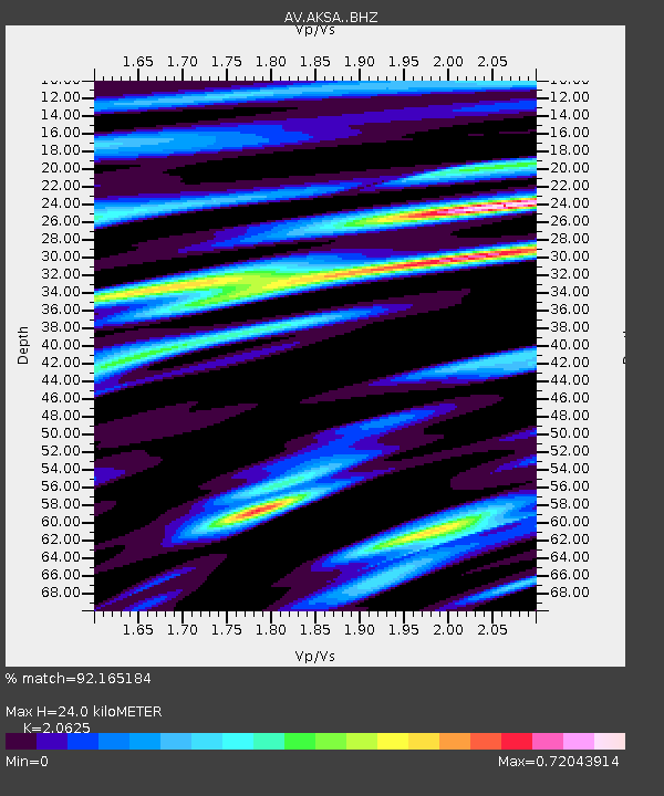
| Estimated Moho Depth: |
24.0 km |
| Estimated Crust Vp/Vs: |
2.06 |
| Assumed Crust Vp: |
5.989 km/s |
| Estimated Crust Vs: |
2.904 km/s |
| Estimated Crust Poisson's Ratio: |
0.35 |
|
| Radial Match: |
92.165184 % |
| Radial Bump: |
400 |
| Transverse Match: |
86.52242 % |
| Transverse Bump: |
400 |
| SOD ConfigId: |
7422571 |
| Insert Time: |
2019-04-22 07:57:46.026 +0000 |
| GWidth: |
2.5 |
| Max Bumps: |
400 |
| Tol: |
0.001 |
|
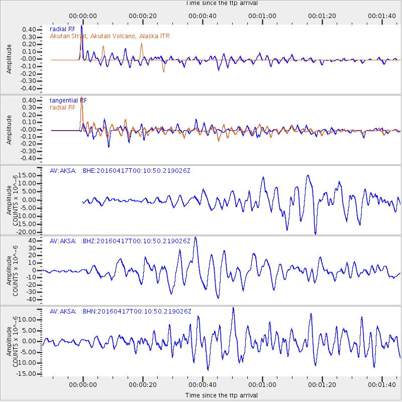
Signal To Noise
| Channel | StoN | STA | LTA |
| AV:AKSA: :BHZ:20160417T00:10:50.219026Z | 3.0420797 | 3.540124E-6 | 1.1637184E-6 |
| AV:AKSA: :BHN:20160417T00:10:50.219026Z | 1.37477 | 1.5030712E-6 | 1.0933254E-6 |
| AV:AKSA: :BHE:20160417T00:10:50.219026Z | 2.277674 | 2.3972002E-6 | 1.0524774E-6 |
| Arrivals |
| Ps | 4.3 SECOND |
| PpPs | 12 SECOND |
| PsPs/PpSs | 16 SECOND |


