You are here: Home > Network List > AZ - ANZA Regional Network Stations List
> Station SMER AZ.SMER > Earthquake Result Viewer
SMER AZ.SMER - Earthquake Result Viewer
| Earthquake location: |
Near Coast Of Ecuador |
| Earthquake latitude/longitude: |
0.4/-79.9 |
| Earthquake time(UTC): |
2016/04/16 (107) 23:58:37 GMT |
| Earthquake Depth: |
19 km |
| Earthquake Magnitude: |
7.8 MWW, 7.4 MI |
| Earthquake Catalog/Contributor: |
NEIC PDE/NEIC COMCAT |
|
| Network: |
AZ ANZA Regional Network |
| Station: |
SMER AZ.SMER |
| Lat/Lon: |
33.46 N/117.17 W |
| Elevation: |
355 m |
|
| Distance: |
48.0 deg |
| Az: |
317.107 deg |
| Baz: |
125.498 deg |
| Ray Param: |
0.06961365 |
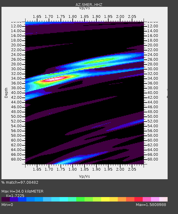
| Estimated Moho Depth: |
34.0 km |
| Estimated Crust Vp/Vs: |
1.72 |
| Assumed Crust Vp: |
6.264 km/s |
| Estimated Crust Vs: |
3.636 km/s |
| Estimated Crust Poisson's Ratio: |
0.25 |
|
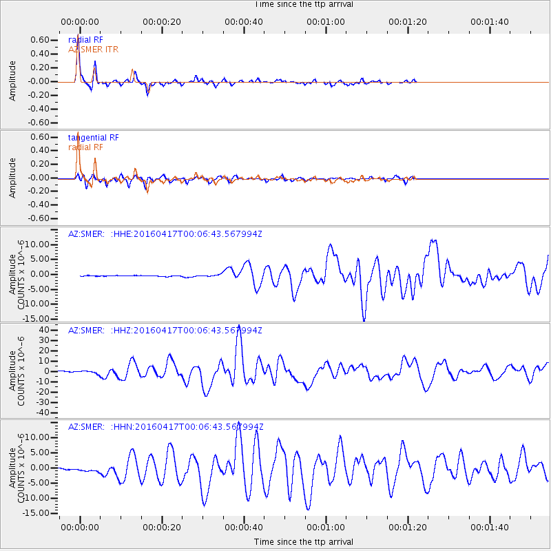
| Radial Match: |
97.08482 % |
| Radial Bump: |
205 |
| Transverse Match: |
93.04971 % |
| Transverse Bump: |
363 |
| SOD ConfigId: |
7422571 |
| Insert Time: |
2019-04-22 07:58:03.926 +0000 |
| GWidth: |
2.5 |
| Max Bumps: |
400 |
| Tol: |
0.001 |
|
Signal To Noise
| Channel | StoN | STA | LTA |
| AZ:SMER: :HHZ:20160417T00:06:43.567994Z | 4.184185 | 1.482769E-6 | 3.543746E-7 |
| AZ:SMER: :HHN:20160417T00:06:43.567994Z | 3.4961228 | 1.4494975E-6 | 4.1460143E-7 |
| AZ:SMER: :HHE:20160417T00:06:43.567994Z | 4.622354 | 6.1426607E-7 | 1.328903E-7 |
| Arrivals |
| Ps | 4.2 SECOND |
| PpPs | 14 SECOND |
| PsPs/PpSs | 18 SECOND |


