You are here: Home > Network List > C1 - Red Sismologica Nacional Stations List
> Station BO02 Daracena > Earthquake Result Viewer
BO02 Daracena - Earthquake Result Viewer
| Earthquake location: |
Near Coast Of Ecuador |
| Earthquake latitude/longitude: |
0.4/-79.9 |
| Earthquake time(UTC): |
2016/04/16 (107) 23:58:37 GMT |
| Earthquake Depth: |
19 km |
| Earthquake Magnitude: |
7.8 MWW, 7.4 MI |
| Earthquake Catalog/Contributor: |
NEIC PDE/NEIC COMCAT |
|
| Network: |
C1 Red Sismologica Nacional |
| Station: |
BO02 Daracena |
| Lat/Lon: |
34.79 S/70.78 W |
| Elevation: |
886 m |
|
| Distance: |
36.0 deg |
| Az: |
167.128 deg |
| Baz: |
344.296 deg |
| Ray Param: |
0.07688768 |
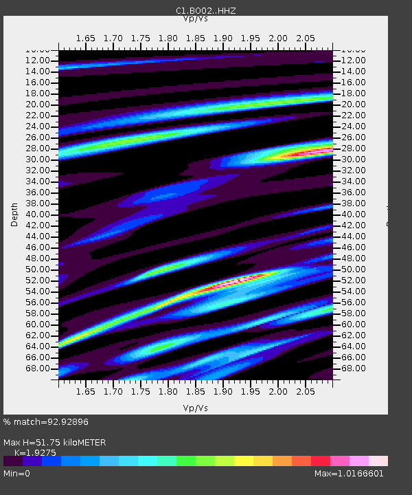
| Estimated Moho Depth: |
51.75 km |
| Estimated Crust Vp/Vs: |
1.93 |
| Assumed Crust Vp: |
6.481 km/s |
| Estimated Crust Vs: |
3.362 km/s |
| Estimated Crust Poisson's Ratio: |
0.32 |
|
| Radial Match: |
92.92896 % |
| Radial Bump: |
400 |
| Transverse Match: |
87.49842 % |
| Transverse Bump: |
400 |
| SOD ConfigId: |
7422571 |
| Insert Time: |
2019-04-22 07:58:25.742 +0000 |
| GWidth: |
2.5 |
| Max Bumps: |
400 |
| Tol: |
0.001 |
|

Signal To Noise
| Channel | StoN | STA | LTA |
| C1:BO02: :HHZ:20160417T00:05:05.967988Z | 28.859255 | 8.741179E-6 | 3.0289E-7 |
| C1:BO02: :HHN:20160417T00:05:05.967988Z | 13.704846 | 5.0099243E-6 | 3.6555855E-7 |
| C1:BO02: :HHE:20160417T00:05:05.967988Z | 7.6766562 | 3.012923E-6 | 3.9247857E-7 |
| Arrivals |
| Ps | 7.9 SECOND |
| PpPs | 22 SECOND |
| PsPs/PpSs | 30 SECOND |


