You are here: Home > Network List > C1 - Red Sismologica Nacional Stations List
> Station MG05 Puerto Natales > Earthquake Result Viewer
MG05 Puerto Natales - Earthquake Result Viewer
| Earthquake location: |
Near Coast Of Ecuador |
| Earthquake latitude/longitude: |
0.4/-79.9 |
| Earthquake time(UTC): |
2016/04/16 (107) 23:58:37 GMT |
| Earthquake Depth: |
19 km |
| Earthquake Magnitude: |
7.8 MWW, 7.4 MI |
| Earthquake Catalog/Contributor: |
NEIC PDE/NEIC COMCAT |
|
| Network: |
C1 Red Sismologica Nacional |
| Station: |
MG05 Puerto Natales |
| Lat/Lon: |
51.68 S/72.50 W |
| Elevation: |
99 m |
|
| Distance: |
52.2 deg |
| Az: |
174.149 deg |
| Baz: |
350.578 deg |
| Ray Param: |
0.06686338 |
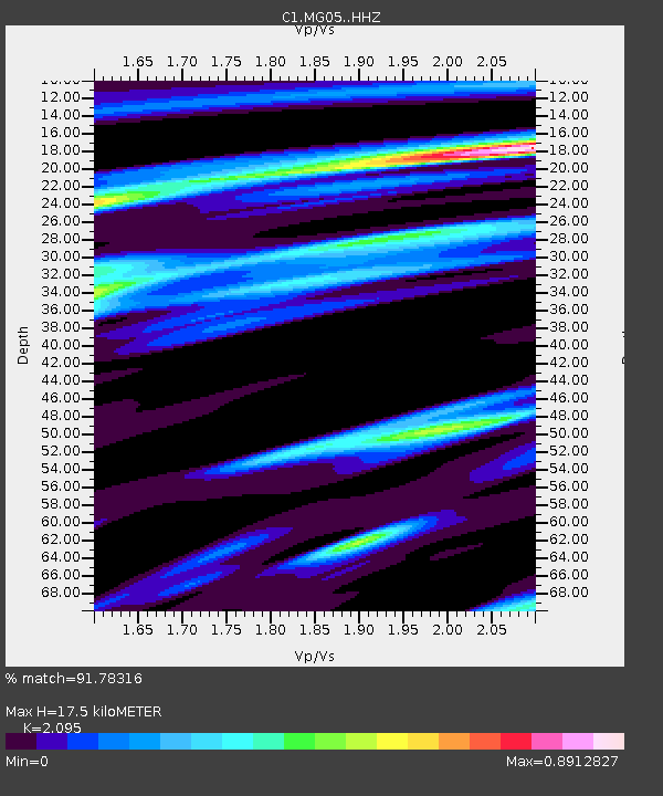
| Estimated Moho Depth: |
17.5 km |
| Estimated Crust Vp/Vs: |
2.10 |
| Assumed Crust Vp: |
6.438 km/s |
| Estimated Crust Vs: |
3.073 km/s |
| Estimated Crust Poisson's Ratio: |
0.35 |
|
| Radial Match: |
91.78316 % |
| Radial Bump: |
319 |
| Transverse Match: |
74.939125 % |
| Transverse Bump: |
400 |
| SOD ConfigId: |
7422571 |
| Insert Time: |
2019-04-22 07:58:35.956 +0000 |
| GWidth: |
2.5 |
| Max Bumps: |
400 |
| Tol: |
0.001 |
|

Signal To Noise
| Channel | StoN | STA | LTA |
| C1:MG05: :HHZ:20160417T00:07:15.699983Z | 3.9888928 | 9.100708E-6 | 2.2815123E-6 |
| C1:MG05: :HHN:20160417T00:07:15.699983Z | 2.021352 | 2.9610067E-6 | 1.4648643E-6 |
| C1:MG05: :HHE:20160417T00:07:15.699983Z | 1.2737393 | 2.0308962E-6 | 1.5944363E-6 |
| Arrivals |
| Ps | 3.1 SECOND |
| PpPs | 8.0 SECOND |
| PsPs/PpSs | 11 SECOND |


