You are here: Home > Network List > C1 - Red Sismologica Nacional Stations List
> Station MT02 Curacavi > Earthquake Result Viewer
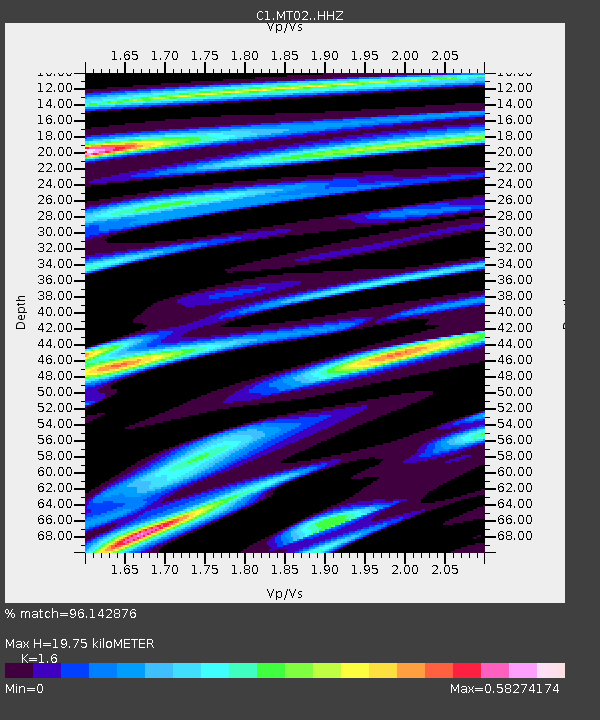
MT02 Curacavi - Earthquake Result Viewer
| Earthquake location: |
Near Coast Of Ecuador |
| Earthquake latitude/longitude: |
0.4/-79.9 |
| Earthquake time(UTC): |
2016/04/16 (107) 23:58:37 GMT |
| Earthquake Depth: |
19 km |
| Earthquake Magnitude: |
7.8 MWW, 7.4 MI |
| Earthquake Catalog/Contributor: |
NEIC PDE/NEIC COMCAT |
|
| Network: |
C1 Red Sismologica Nacional |
| Station: |
MT02 Curacavi |
| Lat/Lon: |
33.26 S/71.14 W |
| Elevation: |
338 m |
|
| Distance: |
34.5 deg |
| Az: |
166.905 deg |
| Baz: |
344.312 deg |
| Ray Param: |
0.07770651 |
| Estimated Moho Depth: |
19.75 km |
| Estimated Crust Vp/Vs: |
1.60 |
| Assumed Crust Vp: |
6.481 km/s |
| Estimated Crust Vs: |
4.05 km/s |
| Estimated Crust Poisson's Ratio: |
0.18 |
|
| Radial Match: |
96.142876 % |
| Radial Bump: |
306 |
| Transverse Match: |
80.61641 % |
| Transverse Bump: |
400 |
| SOD ConfigId: |
7422571 |
| Insert Time: |
2019-04-22 07:58:37.237 +0000 |
| GWidth: |
2.5 |
| Max Bumps: |
400 |
| Tol: |
0.001 |
|

Signal To Noise
| Channel | StoN | STA | LTA |
| C1:MT02: :HHZ:20160417T00:04:52.639985Z | 27.58768 | 9.353298E-6 | 3.3903893E-7 |
| C1:MT02: :HHN:20160417T00:04:52.639985Z | 13.082333 | 5.9562008E-6 | 4.5528583E-7 |
| C1:MT02: :HHE:20160417T00:04:52.639985Z | 6.571216 | 1.7481565E-6 | 2.660324E-7 |
| Arrivals |
| Ps | 2.0 SECOND |
| PpPs | 7.3 SECOND |
| PsPs/PpSs | 9.3 SECOND |


