You are here: Home > Network List > IU - Global Seismograph Network (GSN - IRIS/USGS) Stations List
> Station JOHN Johnston Island, USA > Earthquake Result Viewer
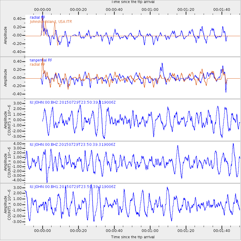
JOHN Johnston Island, USA - Earthquake Result Viewer
*The percent match for this event was below the threshold and hence no stack was calculated.
| Earthquake location: |
Near East Coast Of Australia |
| Earthquake latitude/longitude: |
-25.4/154.2 |
| Earthquake time(UTC): |
2015/07/29 (210) 23:41:40 GMT |
| Earthquake Depth: |
10 km |
| Earthquake Magnitude: |
5.7 MB |
| Earthquake Catalog/Contributor: |
NEIC PDE/NEIC ALERT |
|
| Network: |
IU Global Seismograph Network (GSN - IRIS/USGS) |
| Station: |
JOHN Johnston Island, USA |
| Lat/Lon: |
16.73 N/169.53 W |
| Elevation: |
2.0 m |
|
| Distance: |
54.8 deg |
| Az: |
43.905 deg |
| Baz: |
220.874 deg |
| Ray Param: |
$rayparam |
*The percent match for this event was below the threshold and hence was not used in the summary stack. |
|
| Radial Match: |
53.797672 % |
| Radial Bump: |
400 |
| Transverse Match: |
50.25118 % |
| Transverse Bump: |
400 |
| SOD ConfigId: |
1085051 |
| Insert Time: |
2015-08-12 23:53:03.245 +0000 |
| GWidth: |
2.5 |
| Max Bumps: |
400 |
| Tol: |
0.001 |
|
Signal To Noise
| Channel | StoN | STA | LTA |
| IU:JOHN:00:BHZ:20150729T23:50:39.319006Z | 2.1714709 | 2.133451E-6 | 9.824912E-7 |
| IU:JOHN:00:BH1:20150729T23:50:39.319006Z | 0.4795299 | 6.400139E-7 | 1.3346695E-6 |
| IU:JOHN:00:BH2:20150729T23:50:39.319006Z | 1.9092417 | 2.3640766E-6 | 1.238228E-6 |
| Arrivals |
| Ps | |
| PpPs | |
| PsPs/PpSs | |


