You are here: Home > Network List > CI - Caltech Regional Seismic Network Stations List
> Station MPM Manuel Prospect Mine, California, USA > Earthquake Result Viewer
MPM Manuel Prospect Mine, California, USA - Earthquake Result Viewer
| Earthquake location: |
Near Coast Of Ecuador |
| Earthquake latitude/longitude: |
0.4/-79.9 |
| Earthquake time(UTC): |
2016/04/16 (107) 23:58:37 GMT |
| Earthquake Depth: |
19 km |
| Earthquake Magnitude: |
7.8 MWW, 7.4 MI |
| Earthquake Catalog/Contributor: |
NEIC PDE/NEIC COMCAT |
|
| Network: |
CI Caltech Regional Seismic Network |
| Station: |
MPM Manuel Prospect Mine, California, USA |
| Lat/Lon: |
36.06 N/117.49 W |
| Elevation: |
185 m |
|
| Distance: |
49.7 deg |
| Az: |
319.679 deg |
| Baz: |
127.009 deg |
| Ray Param: |
0.06848225 |
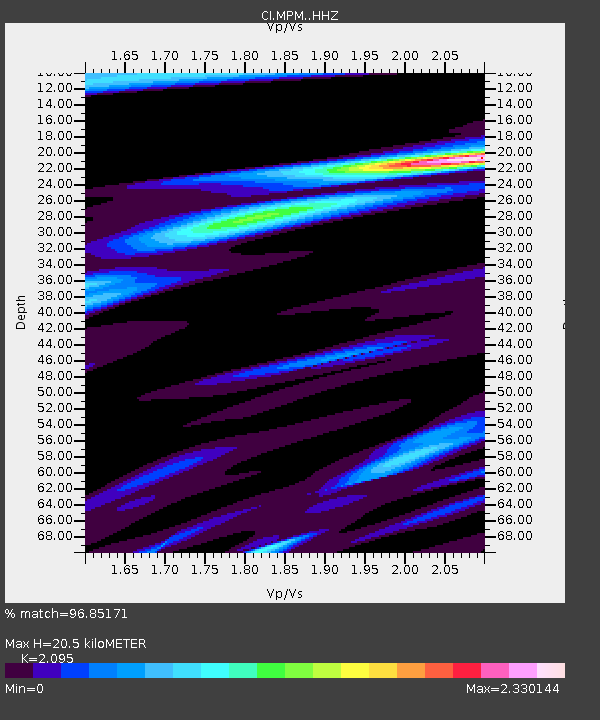
| Estimated Moho Depth: |
20.5 km |
| Estimated Crust Vp/Vs: |
2.10 |
| Assumed Crust Vp: |
6.279 km/s |
| Estimated Crust Vs: |
2.997 km/s |
| Estimated Crust Poisson's Ratio: |
0.35 |
|
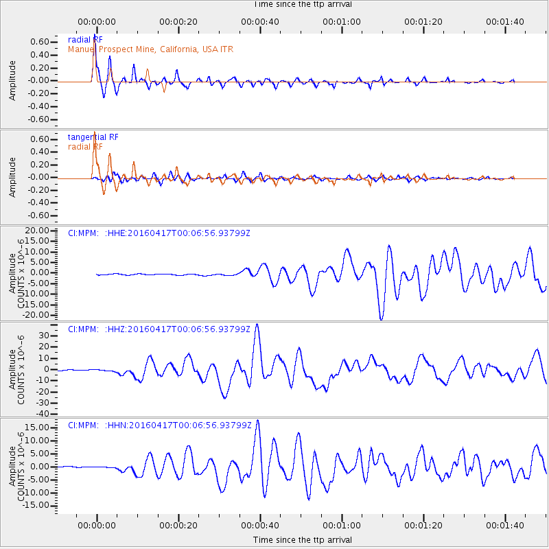
| Radial Match: |
96.85171 % |
| Radial Bump: |
337 |
| Transverse Match: |
89.468834 % |
| Transverse Bump: |
400 |
| SOD ConfigId: |
7422571 |
| Insert Time: |
2019-04-22 07:59:28.820 +0000 |
| GWidth: |
2.5 |
| Max Bumps: |
400 |
| Tol: |
0.001 |
|
Signal To Noise
| Channel | StoN | STA | LTA |
| CI:MPM: :HHZ:20160417T00:06:56.93799Z | 1.8036602 | 6.977265E-7 | 3.868392E-7 |
| CI:MPM: :HHN:20160417T00:06:56.93799Z | 0.50349134 | 1.3596467E-7 | 2.7004373E-7 |
| CI:MPM: :HHE:20160417T00:06:56.93799Z | 1.6940253 | 4.233827E-7 | 2.49927E-7 |
| Arrivals |
| Ps | 3.7 SECOND |
| PpPs | 9.6 SECOND |
| PsPs/PpSs | 13 SECOND |


