You are here: Home > Network List > CI - Caltech Regional Seismic Network Stations List
> Station PDM Parker Dam, Lake Havasu City, AZ, USA > Earthquake Result Viewer
PDM Parker Dam, Lake Havasu City, AZ, USA - Earthquake Result Viewer
| Earthquake location: |
Near Coast Of Ecuador |
| Earthquake latitude/longitude: |
0.4/-79.9 |
| Earthquake time(UTC): |
2016/04/16 (107) 23:58:37 GMT |
| Earthquake Depth: |
19 km |
| Earthquake Magnitude: |
7.8 MWW, 7.4 MI |
| Earthquake Catalog/Contributor: |
NEIC PDE/NEIC COMCAT |
|
| Network: |
CI Caltech Regional Seismic Network |
| Station: |
PDM Parker Dam, Lake Havasu City, AZ, USA |
| Lat/Lon: |
34.30 N/114.14 W |
| Elevation: |
144 m |
|
| Distance: |
46.5 deg |
| Az: |
320.102 deg |
| Baz: |
129.212 deg |
| Ray Param: |
0.070578046 |
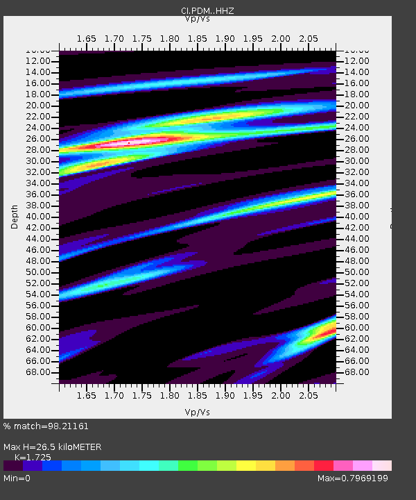
| Estimated Moho Depth: |
26.5 km |
| Estimated Crust Vp/Vs: |
1.73 |
| Assumed Crust Vp: |
6.276 km/s |
| Estimated Crust Vs: |
3.638 km/s |
| Estimated Crust Poisson's Ratio: |
0.25 |
|
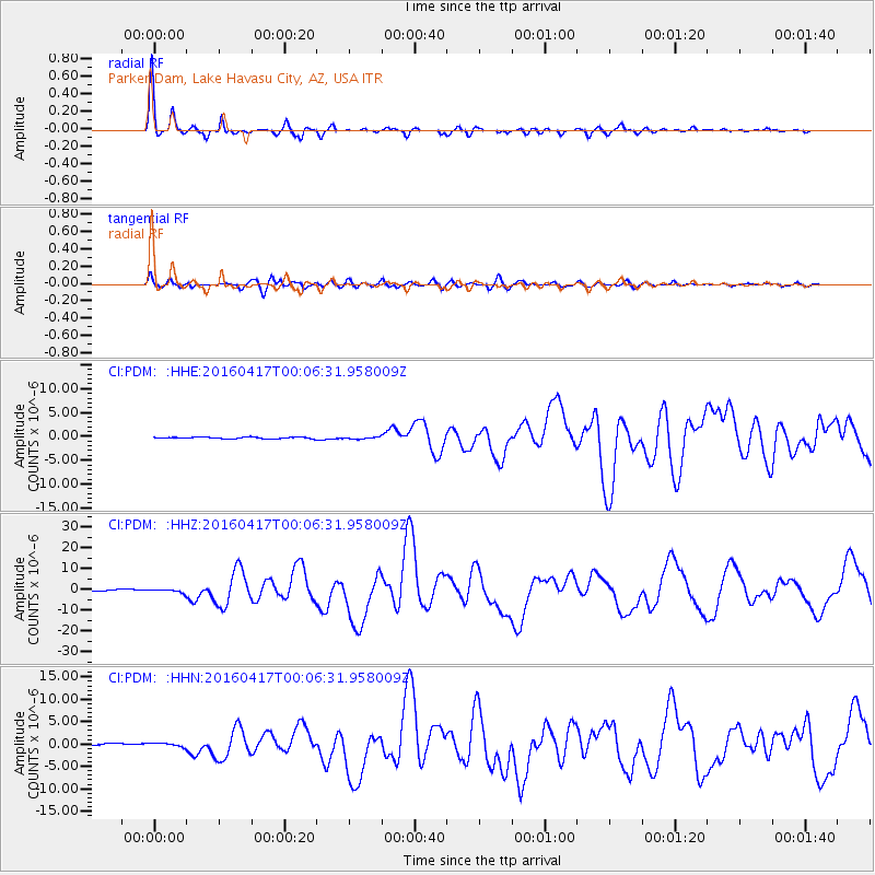
| Radial Match: |
98.21161 % |
| Radial Bump: |
323 |
| Transverse Match: |
85.80976 % |
| Transverse Bump: |
400 |
| SOD ConfigId: |
7422571 |
| Insert Time: |
2019-04-22 07:59:33.725 +0000 |
| GWidth: |
2.5 |
| Max Bumps: |
400 |
| Tol: |
0.001 |
|
Signal To Noise
| Channel | StoN | STA | LTA |
| CI:PDM: :HHZ:20160417T00:06:31.958009Z | 2.8162162 | 7.56165E-7 | 2.6850387E-7 |
| CI:PDM: :HHN:20160417T00:06:31.958009Z | 1.9527934 | 3.751188E-7 | 1.9209344E-7 |
| CI:PDM: :HHE:20160417T00:06:31.958009Z | 1.5666895 | 2.7425753E-7 | 1.7505545E-7 |
| Arrivals |
| Ps | 3.3 SECOND |
| PpPs | 11 SECOND |
| PsPs/PpSs | 14 SECOND |


