You are here: Home > Network List > CN - Canadian National Seismograph Network Stations List
> Station PNPO PUKASKWA, ON > Earthquake Result Viewer
PNPO PUKASKWA, ON - Earthquake Result Viewer
| Earthquake location: |
Near Coast Of Ecuador |
| Earthquake latitude/longitude: |
0.4/-79.9 |
| Earthquake time(UTC): |
2016/04/16 (107) 23:58:37 GMT |
| Earthquake Depth: |
19 km |
| Earthquake Magnitude: |
7.8 MWW, 7.4 MI |
| Earthquake Catalog/Contributor: |
NEIC PDE/NEIC COMCAT |
|
| Network: |
CN Canadian National Seismograph Network |
| Station: |
PNPO PUKASKWA, ON |
| Lat/Lon: |
48.60 N/86.28 W |
| Elevation: |
219 m |
|
| Distance: |
48.3 deg |
| Az: |
354.365 deg |
| Baz: |
171.495 deg |
| Ray Param: |
0.06939675 |
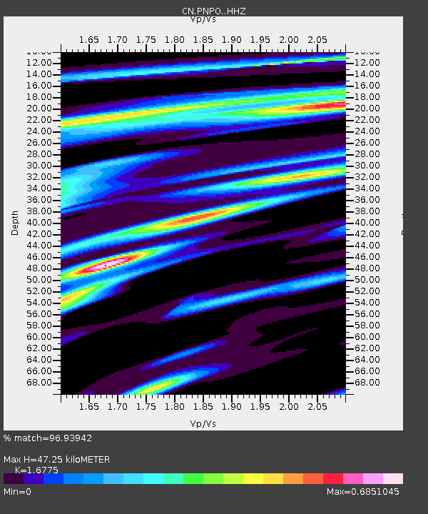
| Estimated Moho Depth: |
47.25 km |
| Estimated Crust Vp/Vs: |
1.68 |
| Assumed Crust Vp: |
6.472 km/s |
| Estimated Crust Vs: |
3.858 km/s |
| Estimated Crust Poisson's Ratio: |
0.22 |
|
| Radial Match: |
96.93942 % |
| Radial Bump: |
357 |
| Transverse Match: |
81.46634 % |
| Transverse Bump: |
400 |
| SOD ConfigId: |
7422571 |
| Insert Time: |
2019-04-22 08:00:32.563 +0000 |
| GWidth: |
2.5 |
| Max Bumps: |
400 |
| Tol: |
0.001 |
|

Signal To Noise
| Channel | StoN | STA | LTA |
| CN:PNPO: :HHZ:20160417T00:06:46.160005Z | 29.435827 | 6.422257E-6 | 2.1817823E-7 |
| CN:PNPO: :HHN:20160417T00:06:46.160005Z | 22.256931 | 3.1949153E-6 | 1.4354698E-7 |
| CN:PNPO: :HHE:20160417T00:06:46.160005Z | 1.9486296 | 3.637486E-7 | 1.8666893E-7 |
| Arrivals |
| Ps | 5.3 SECOND |
| PpPs | 18 SECOND |
| PsPs/PpSs | 24 SECOND |


